M 6.2 Earthquake Becomes Alarm of Greater Danger from Southern Java
The M 6.2 earthquake became an alarm to anticipate the threat of a larger earthquake from the Megathrust Zone in southern Java.
This article has been translated using AI. See Original .
About AI Translated Article
Please note that this article was automatically translated using Microsoft Azure AI, Open AI, and Google Translation AI. We cannot ensure that the entire content is translated accurately. If you spot any errors or inconsistencies, contact us at hotline@kompas.id, and we'll make every effort to address them. Thank you for your understanding.
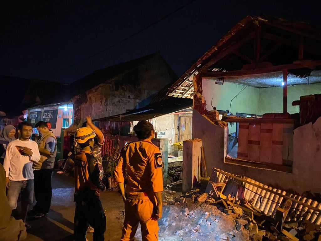
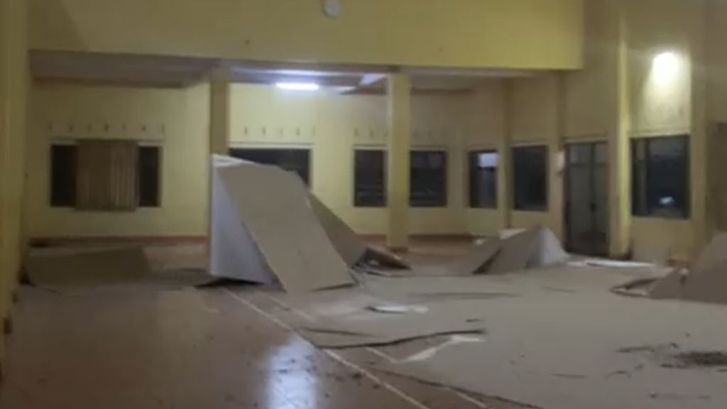
Building damage caused by a magnitude 6.2 earthquake in South West Java. According to the report from BNPB, the total number of houses damaged by the earthquake amounted to 27 units, the majority of which were in the cities of Tasikmalaya and the districts of Tasikmalaya and Garut.
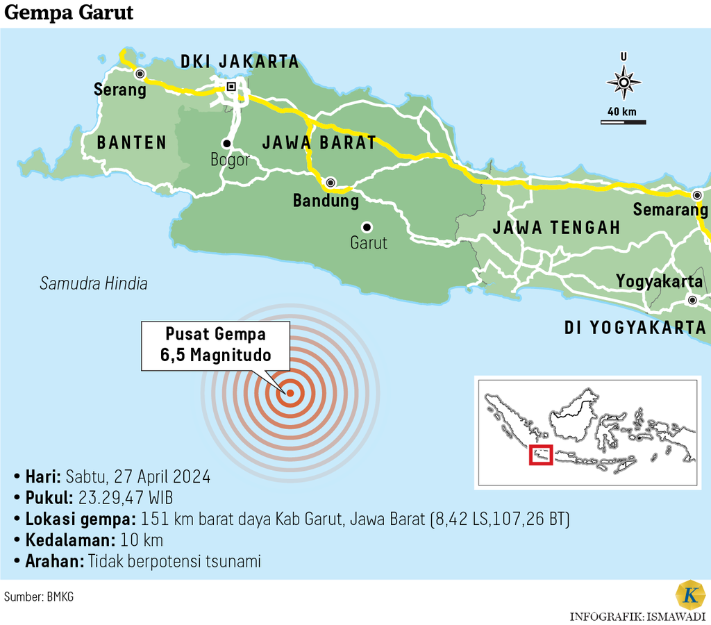
Earthquake measuring M 6.2 centered in the Indian Ocean, southwest of Garut Regency, West Java, on Saturday (27/4/2024) at 23.29 WIB, triggered by a rupture rocks in the plate.
The earthquake tremors felt up to Jakarta have triggered damage in the Garut and Sukabumi areas. The threat of earthquakes greater than those in southern Java can originate from the Megathrust Zone.
Initial information from the Meteorology, Climatology and Geophysics Agency (BMKG) stated that this earthquake had a magnitude of M 6.5 with a depth of 10 kilometers (km).
However, Head of the Earthquake and Tsunami Center of BMKG, Daryono, stated that based on updated data, the earthquake measured M 6.2 with its center at coordinates 8.39 degrees south latitude-107.11 degrees east longitude, with a depth of 70 km.
"By paying attention to the location of the epicenter and the depth of the hypocenter, the earthquake that occurred was a medium-sized earthquake," said Daryono.
This earthquake occurred due to rock deformation activity in the Indo-Australian plate subducting beneath the Eurasian plate south of West Java or popularly known as an intra-slab earthquake (intra-slab earthquake).
Also read: Garut Earthquake M 6.5, Damage in 10 West Java Regions
Hypocenter cross-section data (cross-section) presented by BMKG has shown that the hypocenter of the earthquake in the south of West Java is located within the arm (slab) of the plate. This means that this earthquake did not originate from the area of plate collision or what is known as a megathrust.
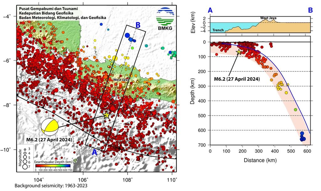
Hypocenter cross-section data (cross-section) shows that the hypocenter of the earthquake south of West Java is located within the Indo-Australian Plate Slab which is subducted beneath the Eurasian Plate. Source: BMKG
The impact of earthquake shocks
Although of moderate strength, the earthquake shock was felt quite widely. BMKG data shows that the areas of Tegalbulued, Pamulihan, Sukanagara, Cempaka, Langkaplancar, and Lembang experienced shaking with an intensity scale of V MMI (Modified Mercalli Intensity).
By paying attention to the location of the epicenter and the depth of the hypocenter, the earthquake that occurred was a medium-sized earthquake.
With this scale, it means that the shock was felt by all residents, items were thrown and poles seemed to sway.
The Sukabumi and Tasikmalaya regions have an intensity scale of IV MMI, which is felt by many people indoors. Meanwhile, the areas of Bandung and Garut experienced tremors with an intensity scale of III-IV MMI.
The areas of Tangerang, Tangerang Selatan, Bogor, DKI Jakarta, Kebumen, Banyumas, Cilacap, and Purwokerto experienced tremors with an intensity of III MMI, meaning that the vibrations could be felt clearly in homes.
The earthquake was also felt in Bantul, Sleman, Kulonprogo, Trenggalek, and Malang with an intensity scale of II MMI, which could cause hanging lightweight objects to sway.
The extent of the impact of this shaking was triggered by the characteristics of the earthquake mechanism. "Intra-slab earthquakes or earthquakes resulting from the rupture of rocks in the slab (arm) of a plate have characteristics of groundmotion (shaking) emissions that are much stronger than earthquakes of the same magnitude from other sources," he said.
The National Disaster Management Agency (BNPB) Operation Control Center has reported building damage in several areas. "As a result of the earthquake, at least four people were injured," said Abdul Muhari, Head of BNPB's Disaster Data, Information, and Communication Center.
Based on BNPB's data, as of Sunday (4/28/2024) at 05.45 AM, 27 families were impacted by the earthquake. Out of this number, the most affected residents were in Garut Regency, with three people experiencing injuries and four families impacted.
Also read: Garut Earthquake: Injured Victims and Damaged Buildings Increase
Meanwhile in Tasikmalaya Regency, one person was injured and eight families were affected, and in Tasikmalaya City five families were affected.
The report also states that the total number of houses damaged by the earthquake is 27 units, including 4 units of heavily damaged houses, 11 units of lightly damaged houses, 5 units of moderately damaged houses, and 7 units of affected houses.
Of the total number, most of the damage was in Tasikmalaya City, Tasikmalaya Regency and Garut Regency.
Threat from South Java
This earthquake serves as a reminder of the M 6.6 earthquake in the Sunda Strait on Friday, January 14, 2022 at 4:05 PM WIB. The earthquake at that time also originated from an intra-slab with a depth of 40 km.
These earthquakes have a different source compared to the earthquakes from the subduction zone with a magnitude of M 7.7 followed by a tsunami that hit Pangandaran on July 17, 2006 at 3:19 PM. The problem is, the earthquakes that occur on the outskirts of this subduction zone are feared to trigger even larger earthquakes.
Several large earthquakes that occur in subduction zones are often preceded by smaller earthquakes on the outskirts of the segment.
Earthquake expert and Dean of the Faculty of Earth Science and Technology at the Bandung Institute of Technology (ITB), Irwan Meilano, stated that the earthquake followed by a tsunami in Tohoku, Japan, in September 2011 was caused by a smaller earthquake at the bottom of the subduction zone.
Before the 2018 earthquake in Palu there were several smaller earthquakes. Also before the 2004 Aceh tsunami, a year earlier there were smaller earthquakes (Kompas, 15 January 2022).
Hypocenter cross-section data (cross-section) shows that the hypocenter of the earthquake south of West Java is located within the Indo-Australian Plate Slab which is subducted beneath the Eurasian Plate. Source: BMKG
In fact, a number of studies have shown that the subduction zone in southern Java has very large earthquake potential.
A study by S Widiantoro from the Global Geophysics Research Group ITB and the team in the journal Nature in 2019 stated that a strong earthquake in the south of West Java and the Sunda Strait could trigger a large tsunami. The height of a tsunami caused by an earthquake in this zone can reach 20 meters and an average of 4.5 meters along the southern coast of Java.
Researchers used earthquake relocation data recorded by BMKG and inversion data from global positioning systems (GPS) to investigate seismic gaps in southern Java Island.
The results of the earthquake relocation indicate a elongated zone between South Java coast and Java Trench that does not have any earthquake activity. The zone is identified as a seismic gap, which is an active earthquake zone that is currently storing energy and has the potential for a major earthquake in the future.
This elongated seismic gap is said to be able to rupture separately or simultaneously during an earthquake. If the segment in southern West Java is detached, an earthquake could have a magnitude of M 8.9 with a repeat period of 400 years.
For the same recurring period, the segments in Central Java and East Java could trigger an earthquake with a magnitude of 8.8 on the Richter scale. If both segments rupture in one earthquake, it will have a magnitude of 9.1 or equivalent to the Aceh earthquake in 2004.
Research published by Pepen Supendi from BMKG and his team in the journal Natural Hazards in 2022 shows that the seismic zone in the south of western Java to the southeast of Sumatra holds a potential source of megathrust earthquakes in the future with strength up to M 8.9. With an earthquake of this size, the maximum potential tsunami height reaches 34 meters.
Also read: M 6.5 Earthquake in Garut Felt in Jakarta and Yogyakarta
Pepen stated that the area with the potential for a maximum height tsunami is Ujung Kulon, Banten. Meanwhile, the average height of tsunamis along the coast of Sumatra and Java respectively is 11.8 meters and 10.6 meters.
One of the buildings affected by the 6.5 magnitude earthquake in Cilawu, Garut Regency, West Java, on Saturday (27/4/2024). According to BMKG analysis, the earthquake occurred at 23:29 WIB.
Based on field surveys reported by Jose C. Borrero in Seismological Research Letters (2005), the height of the tsunami caused by the M 9.1 earthquake in Aceh in 2004 that killed more than 150,000 people at that time ranged from 20-30 meters.
This means that the potential for a maximum tsunami caused by an earthquake in the southern part of Western Java could be higher than Aceh, even if the earthquake is slightly weaker.
Until now, science cannot accurately predict when strong earthquakes will occur.
Nevertheless, earthquakes of smaller scale but causing damage within the plate's arms should serve as an alarm to wake us up to prepare for the greater danger of the earthquake zone in south Java. Moreover, the coastal region of south Java is currently experiencing rapid and dense growth.