Kendari Bay Sedimentation is Increasingly Out of Control
Sedimentation in Kendari Bay makes shallowing uncontrollable. Sediment carries pollutants that can have far-reaching impacts.
This article has been translated using AI. See Original .
About AI Translated Article
Please note that this article was automatically translated using Microsoft Azure AI, Open AI, and Google Translation AI. We cannot ensure that the entire content is translated accurately. If you spot any errors or inconsistencies, contact us at hotline@kompas.id, and we'll make every effort to address them. Thank you for your understanding.
By
SAIFUL RIJAL YUNUS
·4 minutes read
KOMPAS/SAIFUL RIJAL YUNUS
Murky and brownish water can be seen at one of the river estuaries leading to Kendari Bay, Southeast Sulawesi, on Wednesday (8/5/2024). Sedimentation that occurs increasingly damages the bay environment.
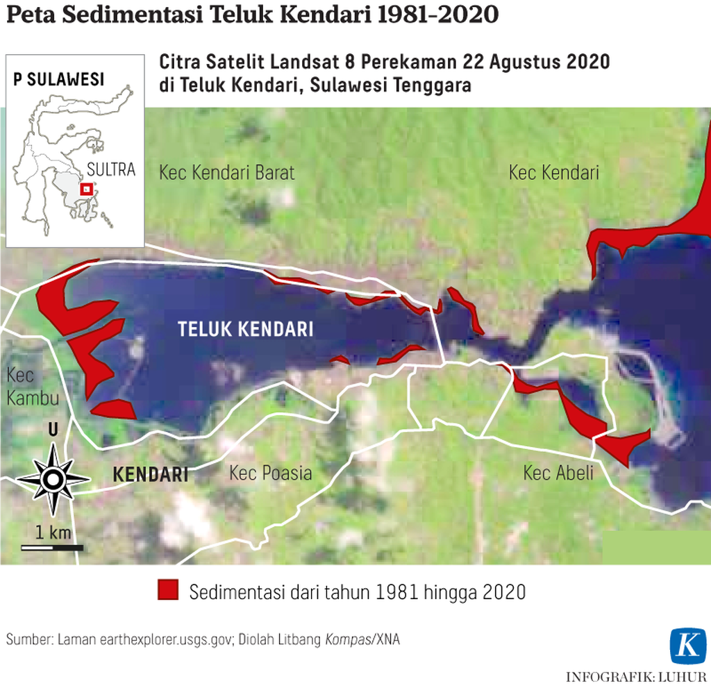
KENDARI, KOMPAS — Sedimentation in Kendari Bay, Southeast Sulawesi, is increasingly uncontrolled and untreated. This condition has an impact on the depth of the remaining bay to around 10 meters, from previously tens of meters. Sediment also carries pollutants such as phosphorus which could one day affect bay and water ecosystems.
Young Expert Researcher from the Center for Limnology and Water Resources Research (PR LSDA) at the National Research and Innovation Agency (BRIN), Siti Aisyah, explains that based on her research, sedimentation in the bay area continues to occur, making the bay increasingly shallow. The current depth of the bay is around 10 meters, which is in line with several previous studies that have recorded the depth of the bay at that level.
"Based on our measurements taken at five points in the bay, the depth ranges from 8 meters to 12 meters. We took samples at the river estuary and the bay estuary," said Aisyah, contacted from Kendari on Wednesday (8/5/2024).
In mid-2021 to 2022, he conducted research in Kendari Bay. This research specifically focuses on the characteristics of phosphate sorption in Kendari Bay. The results of his research were published early this May.
Based on previous research by other researchers, added Aisyah, the depth of the bay area reached 23 meters in 2003. However, the depth of the bay continues to decrease to around 10 meters. This occurs due to silting caused by the sedimentation process.
KOMPAS/SAIFUL RIJAL YUNUS
Fishermen cross the murky and brown waters of Kendari Bay, in Kendari, Southeast Sulawesi, on Wednesday (8/5/2024). The sedimentation that occurs has caused further damage to the bay's environment.
According to Aisyah, the sample characterization results show that the sediment in Kendari Bay contains a very high mud texture, reaching 80 percent. This sediment also has a fairly high content of organic matter, up to almost 70 percent, as well as a high content of iron (Fe) metal reaching 9 mg/g. Phosphorus fractionation shows that calcium-bound phosphorus has the highest concentration followed by iron-bound phosphorus.
"As we know, sediment carries pollutants, one of which is phosphorus. "On the one hand, this phosphorus is indeed beneficial for plants in the water, but if it is excessive, algae blooming will occur one day which will have an impact on the bay ecosystem as a whole," he said.
This situation, he continued, will continue to worsen if there is no significant intervention. If sedimentation continues to increase, the environment will continue to be disrupted. Moreover, if the bay is no longer able to recover from the pollutants that are dissolved in it.
Therefore, control efforts must continue, especially in controlling sedimentation from upstream due to improper land use. In addition, community waste that also flows into the bay must be handled maximally. Household waste contributes to pollutants, one of which is phosphorus.
"Of course, this is a cross-sectoral work, ranging from environmental management, land use in the bay, to management upstream. Because if not addressed, the condition of the bay will deteriorate further," he said.
KOMPAS/SAIFUL RIJAL YUNUS
The flow of the Wanggu River, which empties into Kendari Bay, carries massive sedimentation as seen on Friday (26/3/2021) in Kendari, Southeast Sulawesi. Sedimentation and reclamation over the past few decades have made the 900-hectare bay area critical.
In addition to household waste, sedimentation in Kendari Bay comes from 13 rivers that flow into this 29.5 square kilometer area. These rivers carry sand and mud deposits from activities in the upstream areas or along the riverbanks.
A research conducted by Catrin Sudardjat, M Syahril BK, and Hadi Kardhana in 2011, as reported on the LPPM Institut Teknologi Bandung (ITB) website, shows that Sungai Wanggu, which dominates a watershed area of 339.73 square kilometers, is the largest contributor to sedimentation in Teluk Kendari. The sedimentation from the river reaches 143,147 cubic meters per year or approximately 143 million tons.
The main problem is sediment that continues to come due to damage upstream or community activities.
In addition to the sedimentation rate, the change in the river delta from 2000 to 2011 was 22 centimeters. Currently, sedimentation has reached the river stream, putting the ecosystem in the river area also at risk.
The results of research conducted by the River Basin Management Agency (BPDAS) Sampara stated that within a period of 13 years, there has been a 101.8-hectare shallow area in Kendari Bay with a sea depth ranging from 9 to 10 meters. The area of the bay itself has decreased from its original 1,186.2 hectares to 1,084.4 hectares in 2000. This situation was exacerbated by the decline of mangrove cover due to land occupation.
When contacted separately, Head of BPDAS Sampara Azis Ahsoni on Thursday (9/5/2024) explained that the impact of sedimentation is the occurrence of shallowness in the bay, both at river estuaries and at the bay's mouth. The depth of the bay has drastically decreased after being hit by large amounts of sediment for years.
According to Azis, if there is no intervention, sedimentation is guaranteed to continue to flow and fill the bay. The impact of sedimentation continues to occur, both reducing the bay's ability to store water and disturbing the ecosystem in this area.
One of the issues with watershed rehabilitation that has been carried out so far, he added, is the difficulty in finding land around the riverbanks. These lands have turned into large-scale plantations, residential areas, and other activities.
“Existing retention ponds can reduce sediment and flooding, but that's not where the problem lies. The main problem is sediment that continues to come due to damage upstream or community activities. "Meanwhile, we are having difficulty handling watersheds in mainland Sultra because of limited land," said Azis.