Between January and mid-February 2017, for example, about 460 natural disasters in the form of floods, landslides and tornados occurred. These natural disasters claimed many victims. At least 60 people have died, 178 people have been injured and another 492,642 people were displaced.
In Cirebon, West Java, for example, 34 villages located across 10 districts have been inundated since Wednesday. The water in some areas reached 1.5 meters’ deep.
"This is the worst flood. In just one hour, the water reached 1 meter. Previous floods were not like this," said Kuswara, a resident of Pengarengan, Pangenan district, eastern Cirebon regency, whose house was inundated by water on Thursday.
Mochlas, head of Pangenan district, said that last year the floods had only affected three villages. "Now, nine villages are inundated by the floods," he noted.
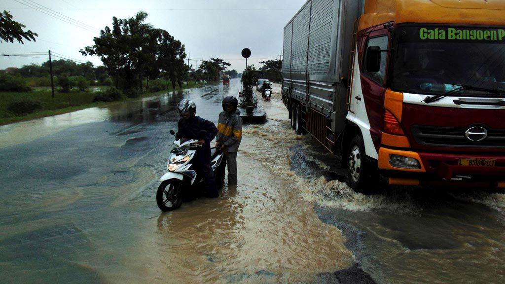
Based on Cirebon Disaster Mitigation Agency (BPBD) records, around 42,000 people were affected by the floods, while the data on the number of evacuees was being calculated. Flooding in Cirebon also affected the northern coastal road, including the Kanci highway, near the Kanci toll gate, reaching as deep as 50 centimeters.
The line of vehicles stretched for 2 kilometers, forcing the police to impose a counter flow traffic system. In Jakarta, although the rainfall was not too high, the Ciliwung River has been running high since Wednesday. Floods hit many areas, including Kampung Melayu, Kramatjati and Bukit Duri, although a few hours later the water had quickly receded. Approximately 7,788 residents were affected by the flooding.
In Central Java, the floods that inundated parts of Pati regency continue, while in East Java, continuous rains have caused water levels to rise. The Bangawan Solo River is also running high, causing fear in Bojonegoro.
Alert along Ciliwung
In the city of Bogor, the water level in the Katulampa Dam reached 70 centimeters, putting it at alert level IV."Currently there are no heavy rains in the upstream area. However, the people living along the Ciliwung River must be on alert. Alert level IV means the condition is not normal," said Katulampa Dam guard Andi Sudirman.
In addition to flooding, landslides have also occurred in some areas. On Wednesday, part of the Puncak highway in Bogor was hit by a landslide
In Temanggung regency, Central Java, about 50 meters of the alternative route connecting Semarang and Temanggung were covered in soil two meters thick due to a landslide, causing traffic congestion.
The head of the Meteorology, Climatology and Geophysics (BMKG), Andi Eka Sakya, said in Jakarta at present the rainy season had begun in most parts of Indonesia.
Unlike the situation in 2015, when Indonesia was affected by El Nino and in 2016 when a moderate La Nina took place, at the beginning of 2017, extreme weather conditions were not so visible.
According to BMKG data, the current rainfall, flooding and landslides were being caused by a variety of factors. For some regions, such as Sumbawa and Bali, extreme rains were the dominant factor.
"At present, rainfall is quite extreme in terms of intensity and frequency, while the number of rainy days has significantly declined," said BMKG extreme weather and climate condition researcher Siswanto.
This year, Siswanto said, more extreme rainfall had occurred in eastern Indonesia due to the emergence of turbulence and low pressure areas in the Indian Ocean north of Australia. While for the western region of Indonesia, extreme rainfall was relatively limited.
According to Andi, compared to the beginning of 2016, the rainy season at the beginning of 2017 in Greater Jakarta was still under normal climatology conditions.
According to the BMKG, average rainfall at observation stations in Pondok Betung, Tanjung Priok, Kemayoran, Cengkareng, Citeko and Darmaga was less than 300 millimeters in January. This is far below average rainfall in January 2014, which reached 600-900 mm, while in 2013, average rainfall in January reached 300-600 mm.
Human factor
Andi said that the 12 hours of rainfall on Feb. 16 in West Java, which had the potency to send floods to Jakarta, was not so high. For example, in Katulampa, the rains were relatively heavy, with average rainfall of 84 mm, while in Puncak there was 75.5 mm of rainfall. However, in Depok, there was only 29 mm of rainfall and 42.6 mm in Kebun Raya, 44 mm in Citeko, 36.6 mm in Darmaga and 8.5 mm in Bekasi.
"It is clear that there is another condition, other than rain, which has a significant contribution on the current flooding, at least in Jakarta. There is no single factor to the disaster, but anthropogenic factors are more dominant," he added.
Andi said that anthropogenic, or human, activity such as development was increasingly widespread both in terms of industrial and residential areas that damaged the environmental carrying capacity. As a result, rainwater absorption decreased.
"Ground absorption in Jakarta has dropped sharply to below 20 percent currently," he said.
Head of BNPB’s data information and public relations, Sutopo Purwo Nugroho, said in addition to damage to watersheds, floods in Jakarta were caused by settlement areas along riverbanks. "The rivers are getting shallower, narrower and need to be normalized," he said.
Environmental damage also occurred at Cimanuk Watershed. Based on data from the Environment and Forestry Ministry, approximately 59,970 hectares of the area upstream of the Cimanuk River had changed from protected forest to vegetable farming.
(AIK/IKI/SEM/NIK/EGI/ACI/IRE/RTS)