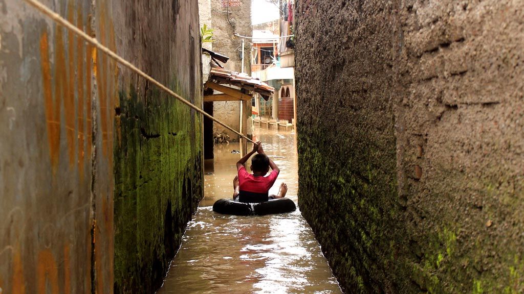
A resident uses an old tire to move across floodwater in Kampung Jambatan, Andir subdistrict, Baleendah district, Bandung regency, West Java, Saturday (18/3). Heavy rain that flushed a number of regions in Bandung on Saturday morning caused renewed flooding in the districts of Baleendah, Dayeuhkolot and Bojongsoang after the water had receded in the preceding days.
JAKARTA, KOMPAS — Development that focuses solely on economic growth has often led to ecological suicide. The development has gone beyond environmental capacity, as shown with the increasing intensity and scale of disaster. Such a situation also deepens the social gap and disadvantages the economy.
An Environmental Impact Analysis (Amdal), which should be able to predict and mitigate the development, often violates spatial planning rules. The environment has often been put on the losing side when facing business interests.
“Amdals are often carried out later after the construction of a project,” said Bogor Institute of Agriculture forestry professor Hariadi Kartodihardjo on Monday (20/3).
Semarang-based Diponegoro University environment management professor Sudharto P Hadi also criticized the poor quality of Amdals, which had contributed to speeding up environmental damage. “Those who draft Amdals generally do not understand that they aim to ensure sustainable development while the assessor is also not critical,” he said.
When visiting the regions during assessment as a member of the Coordination and Supervision Team for the National Movement for the National Resources Conservation-Corruption Eradication Commission (GNPSDA-KPK), Hariadi found many irregularities in Amdals. “For example, we found in Central Kalimantan early this year that the public approval as a prerequisite for Amdal was manipulated. It was made by “buying” copies of identity cards [KTP] from the village heads,” he said.
National Development Planning maritime and natural resources deputy Gellwynn Daniel Hamzah Jusuf said the practices of development often forget the impacts on the environmental capacity. Aside from a lack of understanding among the development actors of the environment issues, the environmental aspect has not become a priority in development. The mechanism of environmental mitigation was made through Amdals.
Government commitment
An Amdal, Sudharto said, was a mechanism in the downstream in mitigating development. In the upstream is spatial planning. Law No. 26/2007 on Spatial Planning stipulates that spatial planning should be based on environmental capacity. Before setting the use of space, for example, there should be strategic environment assessment (KLHS).
The problem is that the government, which has the mandate to carry out a KLHS often ignores it. “The problem is government commitment,” Sudharto said.
Hariadi said spatial planning was often revised to adjust to economic interests or in many cases to smoothen the interests of the extractive industry and corporations. “At the national level, data from GNPSDA-KPK mention the presence of illegal mining in the conservation area of 1.37 million hectares and in the protected forest of 4.94 million hectares,” he said.
In 2016, GNPSDA-KPK also found a forest area in Bogor, West Java spanning 69,902 hectares, of which around 21,739 hectares or 31 percent had been encroached.
The land expansion consists of 455 cultivated lands, 71 land certificates, 12 land swap certificates and 43 permanent buildings.
“Forest encroachment has turned the forest into housing, villas, agriculture land, plantations and roads. In fact, the forests in Bogor regency were crucial for land conservation either to mitigate floods or drought,” he said.
The developmental impact, based on the ecosystem indicative map in the Java eco-region, the water regulator areas were only left in the protected and conservation forests. However, Environment and Forestry Ministry environment impact prevention director Laksmi Wijayanti said the valuable water regulator areas was vulnerable to being transformed into various infrastructure developments such as roads, railway tracks or dams.
Based on data from the National Disaster Mitigation Agency, of 450 rivers (DAS), 118 of them were in critical condition. In fact, 30 years ago, only 22 rivers were in critical and super critical condition.
Poverty
The decreasing environmental capacity along with the increasing disaster intensity cannot be disassociated from poverty and economic disparity issues. “Generally, the ones most affected by disaster are the poor people, mainly if the disaster is triggered by development, which worsens the social gap,” Sudharto said.
The victims become poorer because they lose their property and jobs as their cultivation land or fish ponds were devastated during the disaster. The abrasion in the Sayung district, Demak, Central Java, for example, caused 100 families to lose their fish ponds, rice fields, yards and houses.
In Aceh, a number of people became impoverished and lost their homes, following a flash flood. In Magelang, Central Java, the rice field area decreased after it was eroded by river stream.
Nur Lalila, 32, a resident of Blang Bungong village, Tangse district, Pidie regency, for example, could not rebuild her house after it was damaged during the December 2015 flooding. “The government promises to build the house for the victims. But, there is no realization until today,” she added.