Traces of 300-Year-Old Tsunami Found Near Yogyakarta’s Planned Airport
By
·4 minutes read
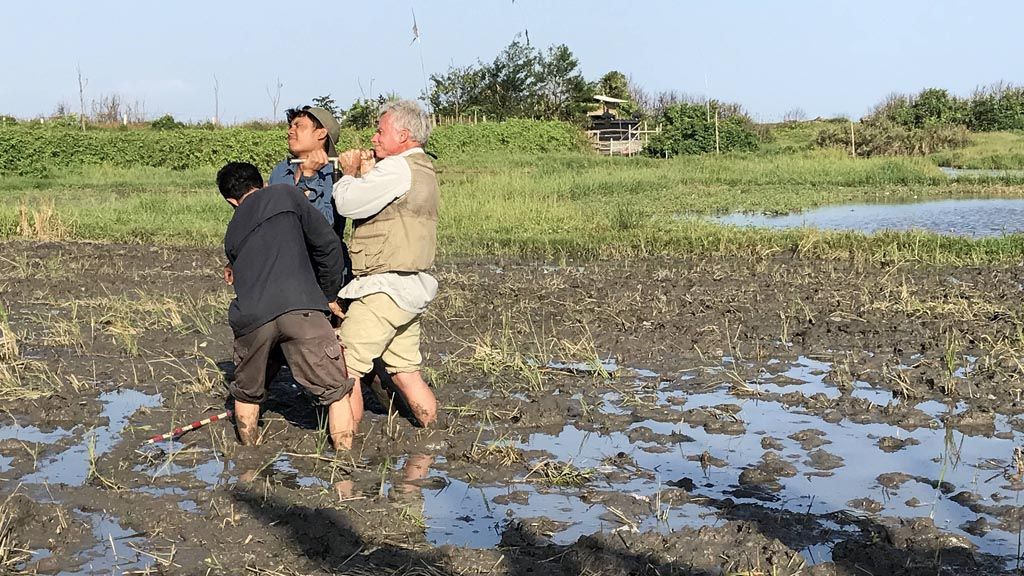
Kompas/Ahmad Arif
An Indonesian-American joint research team on Thursday (14/7) conducts drilling to find traces of tsunamis that occurred in the southern region of Bali. From the samples, which were taken in Banjar Manyar, Ketewel Village, Sukawati District, Gianyar Regency, two layers of sediment allegedly showed that a tsunami had occurred twice in the area. Similar tsunami traces were also found on the southern coast of Java Island.
JAKARTA, KOMPAS - A research team from the Indonesian Institute of Science’s (LIPI) Center of Geotechnology has found tsunami deposits at a site for a planned airport in Yogyakarta.
These traces are believed to be around 300 years old, or as old as other traces found in south Banten and West Java.
The tsunami sediments were found on Congot beach in Karangwuni village, Wates district, Kulon Progo regency.
“The tsunami deposits were found around 2 kilometers offshore. This strengthened our previous survey about the possible occurrence of a tsunami occurring along Java’s southern shores,” LIPI geotechnology center chair Eko Yulianto said in an interview on Sunday.
LIPI paleotsunami researcher Purna Sulastya Putra, who participated in the excavation project, added that a layer of sand between 5 centimeters and 10 cm thick is consistently found between layers of clay. The layers are found at a depth of between 80 cm and 130 cm.
“We have conducted so much research together and we have always found the same layers,” he said.
According to Purna, the theory that the sand layer contains tsunami deposits is strengthened by the discovery of various fossils of foraminifera shells from the sea.
In various paleotsunami research, the fossils of shells — an organic material — are analyzed using radiocarbon to find out when a tsunami occurred in a certain area.
“Based on its depth and the thickness of its layers, the tsunami deposits on the shores of Kulon Progo are most likely the same age as our discoveries in Lebak [Banten], Pangandaran [West Java] and Cilacap [Central Java]. The tsunami deposits in these three regions are estimated to be around 300 years old,” Eko said.
The team also found traces of an old tsunami in Pacitan, East Java, which are currently being examined in a laboratory to ascertain age. Apart from this layer, tsunami deposits around 1,000 years old have also been found in Pangandaran. This shows that there had been multiple tsunamis in the region.
Powerful tsunamis
Based on his intensive paleotsunami research, which had been carried out for the past few years, Eko said that he believed the southern shores of Java had been hit by multiple powerful tsunamis in the past.
“If the region affected spans from Lebak to Cilacap, this is an area within a 500-km range; this means [there must have been] an earthquake of magnitude 9 or higher, or equal to the Japanese tsunami of 2011,” he said.
“Meanwhile, if it turns out that the tsunami in Pacitan is also of the same age, this means that the affected area stretches 800 km.”
In comparison, the Aceh tsunami in 2004 affected 1,300 km of shoreline.
“We are also waiting for the results of a dating test of tsunami deposits discovered by Ron Harris’s team in south Bali. If they turn out to be the same age, it means the tsunami was very big,” he said.
According to Eko, the theory of a 300-year-old tsunami is in line with the huge earthquake recorded by Arthur Wichman (1918) in his catalogue of earthquakes in the Indonesian archipelago between 1538 and 1877. The catalogue stated that a huge earthquake hit Java on Jan. 5, 1699.
Wichman said that the powerful earthquake struck at 1:30 a.m., destroying many buildings in Batavia (Jakarta) on Java’s north shore. The earthquake was also said to have triggered a major landslide at Mount Gede Pangrango and Mount Salak in West Java.
Flash floods carrying mud and wood filled Ciliwung river in Batavia and flowed into the sea. Destruction was everywhere.
Wichman did not mention the source of the earthquake, but considering its strength and impacted area, it is believed to have occurred at the subduction zone to the south of Java.
“It is believed that this earthquake caused a tsunami on the southern shore of West Java and Central Java, and perhaps even further,” Eko said.