On the Trail of the ‘Queen of the South’ in Southern Java
By
AHMAD ARIF
·6 minutes read
Kompas/Ahmad Arif
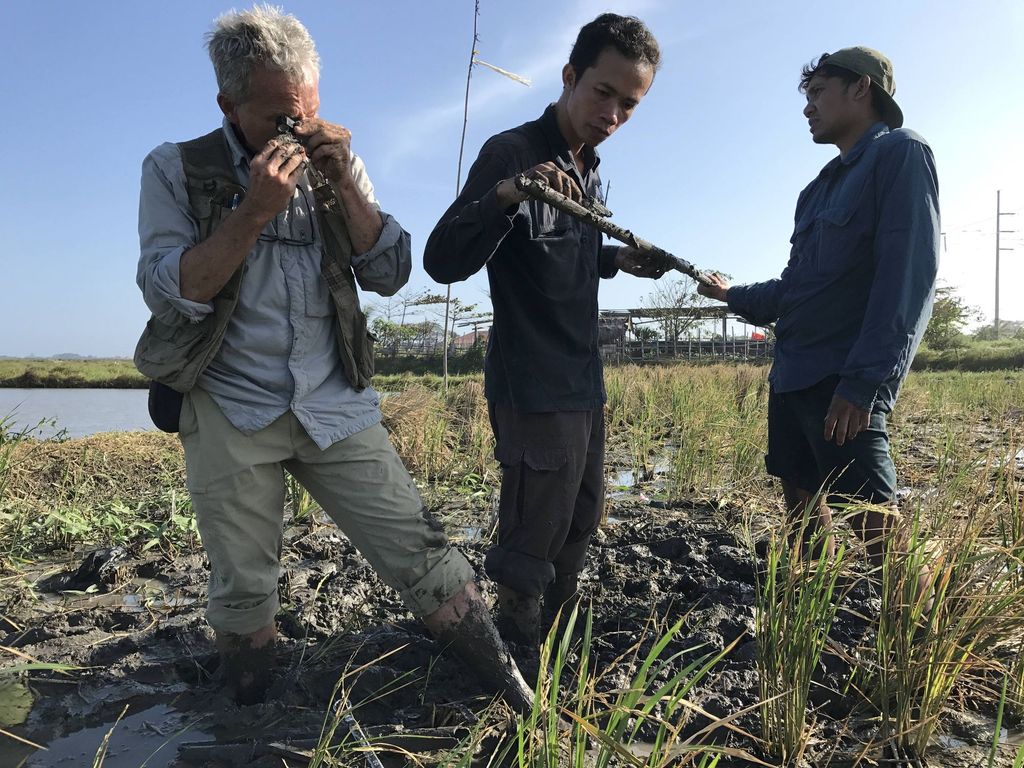
An Indonesian-American research team examines layers of soil on Thursday (14/7) in search of traces of a tsunami that may have happened in the southern region of Bali. Samples taken in Banjar Manyar, Ketewel village, Sukawati district, Gianyar regency, found two layers of sediment that indicate that two tsunamis have occurred in the area in the past.
“...And comes the turbulence. Trees fell, tidal waves as high as the mountains swept through with a roar, the seas boiled, many creatures of the water died. The palace of the southern seas was in mayhem, battered by the storm. The whole of its inhabitants were in chaos. All who lived there felt the risingheat from the power of the knight Sutawijaya as he prayed. The Queen of the South, guardian of the Southern Seas, was worried. Her palace was in the heavens of Dlepih…” –Legends of Java
For centuries, the story about the Queen of the South has been legend, believed by the people along the southern coast of Java. Even in the present day, the people who live on the southern shores of Yogyakarta regularly hold ritual ceremonies and make offerings to the southern sea.
Historian Anthony Reid of the Australian National University has suggested (2012) that the Queen of the South mythology is possibly related to a tsunami. Reid made his hypothesis upon assessing the phrases of the“Dandanggula” poem from Babad Ing Sangkala, a classical text written in 1738 that chronicles the history of Java.
This babad, or chronogram chronicle, is one of the oldest written sources in Java that tells of events that occurred in Java year by year. The manuscript was confiscated by the British Indian troops of lieutenant governor Thomas Stamford Raffles during the attack on Yogyakarta Palace in 1812 and taken to the United Kingdom. University of London historian M.C. Ricklefs transliterated the Babad Ing Sangkala in his book, Modern Javanese Historical Tradition (1978).
Part of the Babad Ing Sangkalasays: ”Nir buta iku/bumi/kala wong Pajang kendhih/ lungo tilar nagara/Adipatinipun angungsi ing Giri Liman/ ing Mataram angalih mring Karta singgih/nir tasik buta tunggal.” (When it disappeared into the ocean/earth/the Pajang people were defeated/they left their lands/their leader took refuge in Giri Liman/in Mataram moved to Karta, when gone/everything back to the sea.)
Some Javanese people, Reid said, associated the description “when all disappeared into the sea” in the Babad with the magical powers of the Queen of the South. However, Reid argued that “Babad Ing Sangkala highlighted the possibility of a huge tsunami hitting the south coast of Central Java (Mataram), the center of the mythology of Queen of the South.”
Geological evidence
Theoretically, the subduction zone beneath the Indian Ocean to the south of Java has the potential for causing huge earthquakes and tsunamis. The zone was formed by the collision of the Indo-Australian and the Eurasian plates, which are moving at a speed of 66 millimeter per year, or 8 mm faster than the movement of the west Sumatra zone. In the collision zone are isolated areas of locked patches that, when they are eventually unlocked,will unleash a high magnitude quake.
McCaffrey in his paper (2008) proposed a new hypothesis about the potential for a mega quake (9.0 magnitude/M) occurring in subduction zones around the world after the Indian Ocean earthquake and tsunami in 2004. The 9.1 M earthquake that hit Sendai, Japan, in 2011 supported this hypothesis. McCaffrey also said that, according to his mathematical calculations,major earthquakes hit southern Java every 675 years and Sumatra every 512 years.
Meanwhile, the latest study by Rahma Hanifa, a researcher at the Bandung Institute of Technology (ITB),says that the tectonic segments along the south of West Java could trigger a quake of up to 8.7 M.
“If the collisions occur at the same time, the segments to the south of Java could trigger a quake of up to 9.2M. This would equal the strength of the Aceh quake in 2014,” said a member of the National Earthquake Center’s mapping team.
Compared to the 7.8 M quake of 2006 that triggered a tsunami in Pangandaran, West Java, the potential for a mega quake southern Java is much higher. Because earthquakes are cyclical, what might happen in the future would have happened in the past. The problem is that the historical records of mega quakes and tsunamis in southern Java are concealed in the Babad and the myth of the Queen of the South.
A recent study by Eko Yulianto, head of the geotechnology center at the Indonesian Institute of Sciences (LIPI), and LIPI paleotsunami researcher Purna Sulastya Putra found important evidence of sedimentary deposits left by paleotsunamis – or prehistoric tsunamis – along the coastline of southern Java. The sediment was found in Lebak (Banten), Pangandaran and Cilacap (Central Java), Pacitan (East Java) and Kulon Progo (Yogyakarta). Some of these deposits are similar in age, dating around 300 years ago. Other layers of sediment are older, which shows a history of recurring tsunamis.
“If the tsunami-affected areas stretched from Lebak to Cilacap, that means a reach of around 500 kilometers. This means the earthquake [that caused the tsunami] was over 9M, similar to the Japan tsunami in 2011. Meanwhile, if the evidence of a tsunami found in Pacitan is of the same period, it means the affected area was around 800 kilometers,” he said.
United States geologist Ron Harris and Purna Sulastya Putra also found tsunami sediment in southern Bali recently. “If the tsunami sediment in southern Bali is from the same period as in southern Java, the tsunami was extremely huge,” Purna said. In comparison, the Aceh tsunami of 2004 hit an area of coastline reaching 1,300 km.
Spatial planning
Legends are always open to multiple interpretations. Yet, a legend has affected the spatial distribution of the people in southern Java. Different from the crowded population areas in northern Java, southern Java is less developed. In addition, the houses in southern Java are located inland.
Based on a Dutch map of the 1880s, Eko said, the houses in southern Central Java and Yogyakarta tended to be located far from the coastline. “The houses are on the northern side of Daendels road,” Eko said.
The road is about 1 kilometer from the coastline and runs parallel to it, spanning 130 kilometers in Karang Sewu, Kulon Progo. The road connects the four regencies of Bantul, Purworejo, Kebumen and Cilacap.
Until the early 1900s, the only area was developing along the southern coast of Java. As Ahmad Wongsosewodjo wrote in his book, Berkeliling Hindia: Tanah Djawa Keradjaan Lama (1937), “along the southern coast of Java, only the port of Cilacap was developed by the government and visited by vessels.”
Today, the southern coast of Java has finally started to develop. In line with the local people’s diminishing fear of the Queen of the South, houses are being built closer to the coast. Furthermore, the government has prioritized the development of southern Java. A trans-Java coastal road, Kulon Progo Airport and a southern trans-Java road of 1,556 kilometers will be developed in the area.
If the Javanese of the past mitigated the threat of the Queen of the South’s wrath by living far from the coastline, the only way to develop the coastal area is by building earthquake-proof structures at an elevation high enough to be safe from potential tsunamis.