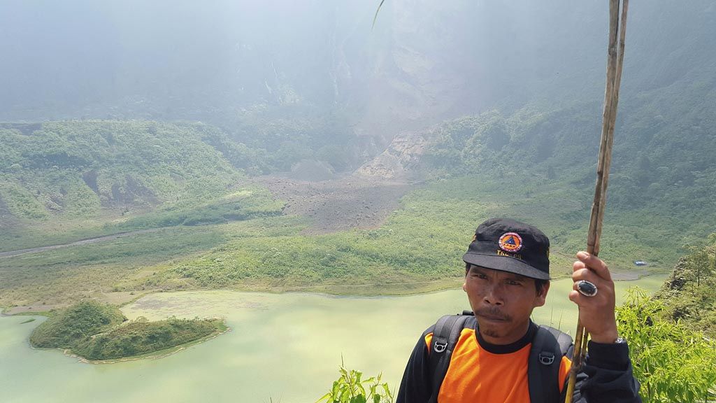
A member of the team monitoring seismic conditions at Mount Galunggung in Tasikmalaya regency, West Java, is seen against the backdrop of the western cliff face that collapsed on Saturday (16/9). The rockslide buried40 hectares of the crater at 40 meters above sea level. Two people have been declared missing, thought to have been buried by the rockslide, and another person was injured by falling rock and debris. The rockslide also damaged a local stall and a musholla prayer room.
KARANGASEM, KOMPAS – The volcano alert status of Mount Agung in Karangasem regency, Bali, was raised from level II (alert) to level III (standby) at 9 p.m. local time on Monday (18/9). There was an increase in the frequency of tremors from Mt Agung.
The statement was made on Monday evening by the head of the information data and public relations center of the National Disaster Mitigation Agency (BNPB), Sutopo Purwo Nugroho, based on the results of visual observation and instrumental analysis from the Mt Agung Observation Post of the Vulcanology and Geological Disaster Mitigation Center (PVMBG) in Randang village, Bali.
Residents of Sebudi village, the village closest to the first observation post on the mountain, started evacuating on Monday evening for fear of a sudden eruption.
The regional government, in cooperation with the Bali Disaster Mitigation Agency (BPBD), urged the public not to panic,assuring that the information they had was correct and accurate. Climbers and tourists were asked to trek or camp outside a 6-kilometer radius from Mt Agung\'s crater.
Earlier, a number of residents began selling their livestock, such as cows and chickens, and withdrawing their savings from village credit institutions (LPDs).
"Three cows were sold to anticipate evacuation. Their prices were low, about Rp 7 million each. If the status of the mountain returns to normal, the animals can be bought back," said Wayan Warsa, a Karangasem resident. Several of Warsa\'s neighbors had withdrawn their savings from the local LPD.
Bali BPBD head Dewa Indra said the provincial government had prepared evacuation routes, locations, trends and logistics in cooperation with the regency/city administration. "The volcanic ash cloud is not visible during the night, but smoke has been visible," said Dewa.
In accordance with its plans, representatives from the Karangasem regency administration, along with the Bali BPBD and Klungkung regency administration as well as volcanology experts, held a coordination meeting on Tuesday (19/9).
Rockslides
The crater of Mt Galunggung in Tasikmalaya regency, West Java, which is still open to tourists,has become dangerous because of rockslides.
On Saturday (16/9), the western cliff of Mt Galunggung’s crater collapsed, burying an area of about 40 hectares at a depth of 40 meters. Two people were believed buried alive in the rockslide, and another person was injured after being hit by falling rocks and debris.
"The upper ridge of the cliff has often collapsed, but this time, the collapse is very big. No one should be allowed to get close to the vertical cliff of the crater,” said PVMBG Mt Galunggung Observation Post head Heri Suparto noon Monday.
The Galunggung crater is located in Linggajati village, Sukaratu district, Tasikmalaya. Based on observations taken at Mount Galunggung’s peak, the cliff was believed to have collapsed from a height of over 500 meters above the crater, which is 2,168 meters above sea level. It takes two hours on foot to reach the affected side of the crater.
It takes 600 steps to climb up to the crater from the parking lot of the Cipanas Galunggung tourist site, located lower down the mountain. The evacuation team, comprising personnel from the Tasikmalaya BPBD, the vulcanology disaster mitigation center,the Indonesian Military (TNI), the National Police,the National Search and Rescue Agency,the Indonesian Red Cross unit of the University of Siliwangi, along with a number of volunteers, are still combing through and mapping the affected area. This must be done because debris from the rockslide, such as sand and large rocks, could collapse further.
Tasikmalaya Regent Uu Ruzhanul Ulum visited the location on Monday with the evacuation team, accompanied by representatives of the Sukaratu district office. ”Two people are believed to have been buried alive. A motorcycle belonging to one of the possible victims was left behind in the parking lot,” said Uu.
This allegation was strengthened by reports from Mekarjaya village head Asep S in Mekarjaya district, Sukaratu district. He received information from Irsa, a villager, that her husband Ajat, 34, had not come home. According to the housewife with one child, her husband hunted birds in the crater area with his neighbor, Dadang Wahyudi, 45, until early evening. However, they had not returned home by 8 p.m. on Saturday.
A number of residents claimed that the rockslide was caused by Cibanjaran waterfall in the area to the north of the landslide. Water from the waterfall, which flows from the peak of the mountain, had seeped into the cliff along the side of the crater, making it unstable.
The rockslide also buried one musholla and a stall belonging to a local villager. The top of the musholla was still visible, but was badly damaged. A resident named Lim of Jalan Gagak kampong in Linggajati village, Sukaratu, was injured when rockslide debris hit his legs.
Still active
Heri Supartono explained that the rockslide was simply the earth shifting, because Mt Galunggung’s condition remained normal. Seismic data and activities were normal, so Mt Galunggung was declared normal. Nevertheless, no one is allowed to stay overnight in the area during the cloudy weather condition. "No one is prevented from approaching the crater lake," he said.
Galunggung crater is visited by many people, especially on Sunday and holidays, because it is a tourist destination managed by the Tasikmalaya administration and the state forestry company. Afee collecting post is at the bottom of the stairs leading to the crater, selling tickets to visitors who with to climb to the crater. Visitors can also fish in the crater\'s lake, which has plenty of fishes.