Coming into December, heavy rains, similar to what was witnessed in Surabaya on Friday (24/11) are predicted to escalate across Java.
By
·6 minutes read
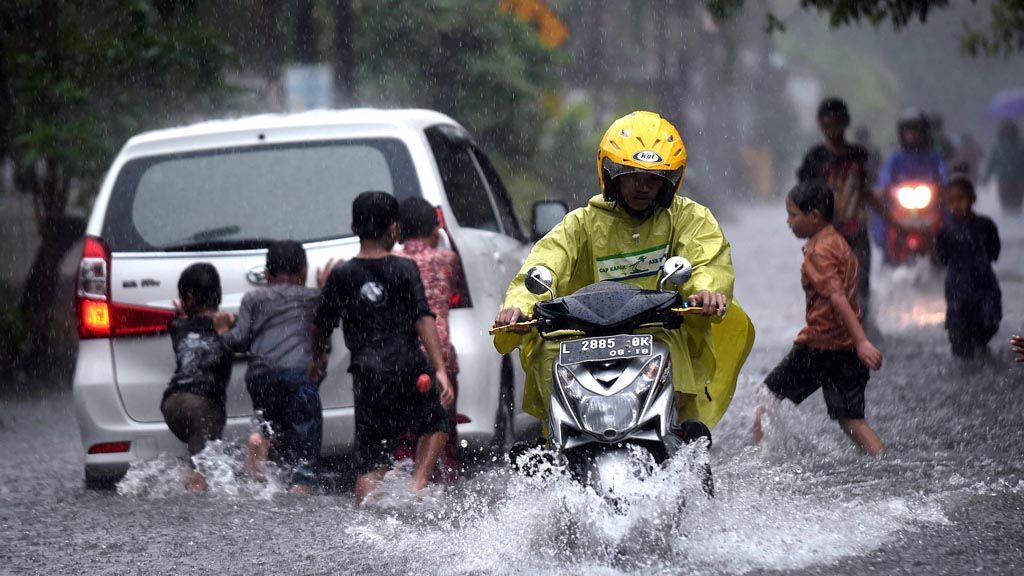
Kompas/Bahana Patria Gupta
Locals attempt to pass through a flood in Ngagel Rejo, Surabaya, on Friday, Nov 24. Heavy rains, which fell for four hours, caused a number of roads in Surabaya to become flooded.
JAKARTA, KOMPAS – Coming into December, heavy rains, similar to what was witnessed in Surabaya, East Java, on Friday (24/11) are predicted to escalate across Java. People are asked to stay alert, particularly those in flood-prone areas.
Heavy rain, lasting for six hours from 10:00 a.m. to 04:00 p.m. in Surabaya, on Friday, caused 50-centimeter deep flooding in a number of places in the city. The high water level made it difficult for people to distinguish between roads and gutters, even though the water appeared to move toward the drainage, as seen on Jalan Ketintang Madya, which was saw 30 cm high flooding.
“Our school has never experienced a flood like this before. It is likely that the water volume at the nearest pump house on Mount Sari had increased and coincided with the coming of the sea tide, so the water did not immediately move,” said Hartini, a teacher at junior high school SMP Baitussalam.
The flooding in the area caused traffic jams along a number of protocol roads such as Jalan A Yani, Jalah Raya Darno, Jalan Diponegoro and Jalan Basuki Rahmat. The traffic only started to ease when the flooding started to recede at 07:30 p.m. One person died of an electric shock after electric cables fell into the water.
According to Siswanto, an extreme weather and climate researcher at the Meteorology, Climatology and Geophysics Agency (BMKG) and Indonesian Geophysics Experts Association, the heavy rain in Surabaya occurred because the wet Asian monsoon season had intensified. This has been caused by the increased pattern of activity in the inter-tropical convergence zone, which is the area where winds from the northern hemisphere meet with those from the southern hemisphere, due to low-pressure activity around the equator.
As December approaches, there is likely to be more heavy rain in Java.
The heavy rain also caused flooding in Nagari Ganggo Hilir area, Bonjol, Pasaman regency, West Sumatera, from Thursday night to Friday morning. The flood that affected 20 houses was the second one in November. On November 16, the flood in Nagari Simpang Tonang, Dua Koto district, destroyed 5 hectares of paddy fields and damaged two bridges.
BMKG Minangkabau head Achadi Subarkah R asked people to be wary of the potential for floods and landslides up until the end of November, which is the peak of the rainy season in West Sumatera.
Landslides are also a danger in a number of areas. Last week in Dayeuhluhur district, Cilacap regency, Central Java, ground movement caused cracks to as many as 21 houses.
“The houses have not collapsed, but their foundations and walls have cracked,” said Panulisan Timur village chief Ujang Haryanto in Banyumas. The fracture in the ground reached 20 centimeters wide.
Other than experiencing ground movement, Matenggeng village in Dayeuhluhur district was also hit by a landslide, which caused parts of the village road to be covered by soil on November 22. The height of the soil heap reached 4 meters, with a length of 12 meters. In Negarajati village, meanwhile, Cimanggu district, the ground caved in, causing two houses to be in danger of collapsing.
Extreme weather
Siswanto reminded that the escalation in extreme weather in a number of areas was caused by increasingly powerful tropical cyclones. According to his research, which is based on 1960-2010 data, there has been a significant increase in the trend of category 3 tropical cyclone formation in the southern part of the Indian Ocean, both in terms of frequency and duration. Category 3 tropical cyclones are strong and destructive. The increasing intensity of tropical cyclone is occurring in particular in the waters of the Indian Ocean.
“The areas that are prone to worsening extreme weather share borders with the Indian Ocean, especially the western part of Sumatera and the south of Java. The weather in these areas is likely to be affected by tropical storms, most of which are centered in the high seas,” Siswanto said.
Regarding the development of cyclones in the south of East Java, he was concerned about the potential for extreme rain and strong winds in Tasikmalaya, Kebumen, Yogyakarta and other southern coastal areas.
More tornados
Based on National Disaster Mitigation Agency (BNPB) data, the occurrence of tornados has also become more extreme. BNPB spokesman Sutopo Purwo Nugroho said that the frequency of tornados had increased in the last 15 years. In fact, tornados have now become the second most frequent disaster after floods. This year alone, there has been 624 cases of tornados, which have killed 30 people, left 166 people injured and forced 13,692 affected people to evacuate. It has also caused damage to 12,607 houses and public buildings.
Based on BNPB data, between 2002-2017, the regions most frequently hit by tornados have been Central Java (1,311 times), East Java (819 times) and West Java (737 times). Meanwhile, at the regency level, the regencies most frequently hit by tornados are Cilacap, Central Java (204 times), Bogor, West Java (162 times) and Bojonegoro, East Java (108 times).
In West Java, in the last month, tornado have hit a number of areas in Bandung city, Cimahi city, Bandung regency and West Bandung regency. As a result, hundreds of houses have been damaged. BMKG Bandung forecaster Muhammad Iid Mujtahidin said there was still potential for strong winds with speeds of 15-25 knots to strike in West Java.
As in the case with tornados, the highest frequency of flooding has also occurred in Java, particularly in East Java, which has witnessed 97 cases of flooding. Central Java sits in second place with 96 cases of flooding, followed by West Java with 58. Meanwhile, the areas that have been most-frequently hit by landslides are Central Java (195 times), West Java (107 times) and East Java (97 times).
Overall, 315 regencies/cities are located in medium-high risk flood-prone regions, with the number of people potentially at risk reaching 63.7 million. Meanwhile, 274 regencies/cities are located in medium-high risk landslide-prone regions, with as many as 40.9 million people potentially at risk.
The domination of floods and landslides in Java, Sutopo said, showed the concerning state of environmental degradation on the island, as well as the rapid growth of the population living in disaster-prone areas. Upstream areas, which are supposed to be protected water catchment areas and hydrology system buffers, have been turned into land for agriculture, plantation, mining and settlements.