The regional administration was called to revise spatial planning in detailed synergy with regencies.
By
·3 minutes read
Kompas/Rony Ariyanto Nugroho
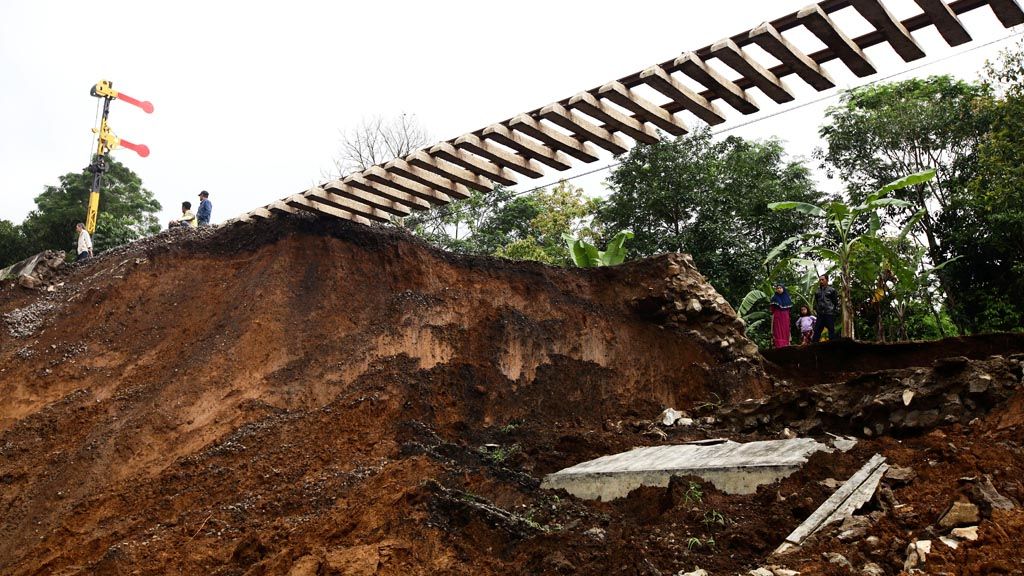
A landslide has destroyed part of the railway line in Warung Menteng, Cijeruk, Bogor regency, West Java. The operations of trains on the Bogor-Sukabumi service was suspended on Wednesday (7/2). Besides disrupting railway services, the landslides that took place on Monday (5/2) also buried five residents alive.
BOGOR, KOMPAS — After three days, the search for victims of a landslide in Riung Gunung, Puncak, Bogor, West Java, was stopped on Wednesday (7/2) night. There was no clear evidence of more victims buried by the landslide. However, the emergency status remains in place until Sunday (18/2).
By then, the Public Works and Public Housing Ministry can hopefully reopen the road affected by the landslide. In the meantime, four-wheel vehicles are not allowed to use the Jakarta-Cianjur road.
Bogor Disaster Mitigation Agency emergency head Sumardi said at the site of the landslide that around 60 agency personnel would be on alert in the vicinity of Riung Gunung.
Bogor Police chief Adj. Sr. Comr. Andy M Dicky Pastika said there were no reports of missing people related to the landslide.
Suryakancana Military Command chief Col. M Hasan added that unclear information from the survivors had contributed to the decision to terminate the search effort.
Latest data point to one fatality related to the landslides in Puncak. In Cijeruk, between Bogor and Sukabumi, five people were killed. In total, therefore, there were six fatalities and no reports of missing people.
A road management official at the Public Works and Public Housing Ministry, Elsa Putra Friandi, said during the 10-day emergency period his office would restore the Gunung Mas-Ciloto road. That work would include retaining the cliffs with bags of sand and with bamboo as well as reducing the height of the cliffs. “We hope to restore road access and conduct permanent repairs within those 10 days,” Friandi added.
Commitment
A commitment to addressing the high intensity of human activity in the protected area of Puncak, Bogor, is needed to prevent landslides. This will include the strict enforcement of rules as well as the use of technology and engineering.
New data point to suboptimal spatial planning and the high intensity of human activity in the protected area as two of 22 factors triggering the landslide in Puncak on Monday (5/2). The data was released during a media gathering related to the Puncak landslide by the Environment and Forestry Ministry’s director general for river management and forest protection, Hilman Nugroho, and river stream planning director Yuliarto Joko Putranto.
Both man-made factors that triggered the landslide occurred in five spots of Puncak. They are around Atta’awun Mosque, Gunung Mas, Grand Hill, Riung Gunung and Widuri, in the upstream area of Ciliwung River.
Other human factors are a lack of public awareness and deforestation. The natural factors identified were rainfall intensity and rainfall duration and various conditions of the slopes in each location.
Meanwhile, cliffs overburdened with buildings were identified in three locations, namely around the Atta’awun Mosque, Grand Hill and Widuri. The five locations being identified bear the status of other utilized areas (APL) with protected forest in higher regions.
Yuliarto said the series of landslides would compel the regional administration to pay more attention. He said rules needed to be enforced strictly, which included the demolition of buildings that are not in line with spatial planning. “Otherwise, landslides will keep happening.”
He noted that this was related to spatial planning, the authority over which was in the hands of the Agrarian and Spatial Planning Ministry. In the past two years, Yuliarto said, his office had worked with the ministry for spatial planning simulations. The regional administration was called to revise spatial planning in detailed synergy with regencies. The proposal includes an assessment of river stream-based spatial planning.