Strong Alarm from Batu
The flash flood in Batu is an alarm for everyone. We may at times have to prioritize ecological preservation for the sake of safety.
TNI personnel and volunteers clean up debris from a flash flood in Sambong Hamlet, Bulukerto Village, Bumiaji District, Batu City, East Java, Friday (5/11/2021).
Flash floods that hit eight villages in Bumiaji district, Batu, East Java, on Thursday (4/11/2021), have shown that the slopes of Mount Arjuno potentially pose a lethal threat to the upstream area of the Brantas River.
The flash floods killed seven people, affected 89 families and damaged 35 houses, seven cars, 73 motorbikes and 10 cattle pens, with 107 heads of cattle affected. As many as 33 houses were submerged in mud. The magnitude of the disaster has shocked the public and the authorities alike.
Incidents in the form of minor landslides, such as on the embankment and road elevation, have so far occurred at several hillslopes in Batu, such as the Payung area in Songgokerto village. A tectonic shift at Brau, Gunungsari village, Batu district, forced a number of residents to evacuate their homes in 2020.
In Batu Utara, Bumiaji district, natural disasters are common but occur on a small scale. Mud spilt over onto the road at Sumberbrantas village following heavy rains. In 2004, downpour caused a flash flood.
Also read:
> Brantas Upstream Region Causes Flooding in Batu City
> When Flash Floods Take Lives
This time around, the flash floods had a massive impact on Bumiaji district, with the severely affected villages including Sumberbrantas, Tulungrejo, Sidomulyo, Sumbergondo, Bulukerto, Bumiaji and Punten.
Bulukerto has suffered the most. Five of the seven people killed in the flash floods came from village located on the southern slopes of Arjuno.
“In Bulukerto, we have never been hit by a disaster like this. A flash flood did occur in 2004, but only in Sumberbrantas,” Bumiaji district head Bambang Hari Suliyan said on Sunday (7/11).
The flash flood in 2004 damaged the Sumberbrantas arboretum, where the Brantas River springs originate. Afterwards, the downpours that occurred every rainy season only triggered minor landslides.
Speaking to media reporters, Batu Mayor Dewanti Rumpoko said areas had expected intense precipitation following a warning over extreme weather up to February 2022. However, she said they had not expected it to build to such a scale that the floods brought massive sludge, including the uprooted logs.
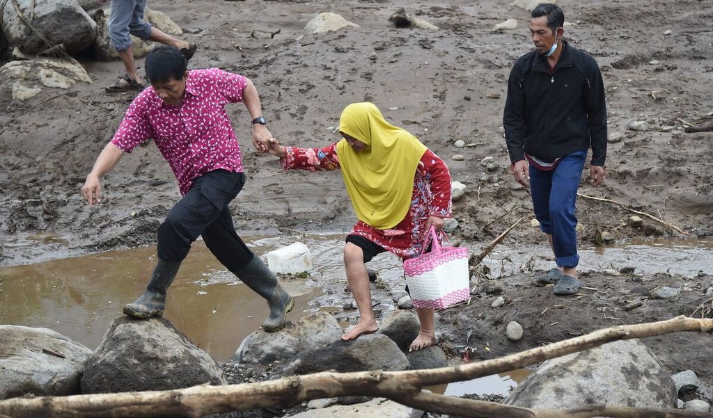
Residents pass through Kali Paron because the bridge broke at the location of a flash flood in Bulukerto Village, Bumiaji District, Batu City, East Java, Friday (11/5/2021). The flash flood occurred on Thursday (4/5/2021) at 15.00 and caused 11 houses to be damaged and 23 houses to be submerged in mud.
Natural leveesA post-flood aerial survey found at least five landslide on the slopes of Arjuno, upstream of the Sambong River. The rainfed river unleashed flooding and sludge material on Thursday following three-hour long torrential rains.
The flash flood was preceded by the collapse of a natural levees that were no longer able to hold the avalanche of material from above.
“The flash flood was believed to be sparked by water accumulation upstream because the watershed was unable to accommodate large amounts of rainwater. Local people say that the flood only lasted 10 to 15 minutes. What has to be looked into is how the water accumulation can happen," Bayu Pramadya
Kurniawan Sakti, an official of the Water Resources Management Working Group for the Indonesian Soil and Water Conservation Society (MKTI) of East Java, said on Saturday.
A study by Didik Suprayono and Sudarno from the East Java MKTI in 2019 said that water accumulation might have been caused forest fires. The Arjuno area suffered bush fires repeatedly in 2019. Other causes were said to be natural phenomena related to the tree life cycle and human activities.
Also read:
> 15 Villages in NTT Targeted for Relocation
The sludge materials swept away in the flash floods came from the Arjuno hillslopes on the southwest-south side.
The floodplains include Sumberbrantas, Tulungrejo, Sumbergondo and Bulukerto. The hills were eroded due to a lack of trees, with the area becoming subject to land clearing for community plantations, tourism and agriculture.
The landscape on the Arjuno hillslopes between Sumberbrantas and Tulungrejo villages is a stretch of agricultural land marked with high and low elevations.
The hillslopes have been cleared for the planting of potatoes, carrots and cabbage, with scarcely planted trees. Many apple plantations have been abandoned because of high costs.
Such conditions are common on the river’s steep slopes. From an aerial view, the Arjuno hillslopes, which are the source of landslides, are relatively open compared to other slopes.
According to data from Perum Jasa Tirta I, which manages the Sumberbrantas arboretum, forest cover on the upper Brantas River remains at only 20 percent, far from the minimum requirement of 50 percent.
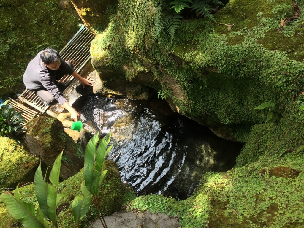
Officers from Perum Jasa Tirta I in charge of preserving the springs of the Brantas River at the Sumberbrantas Arboretum in Sumberbrantas Village, Bumiaji District, Batu City, East Java, Saturday (6/11/2021). The conservation of highland nature has again become a concern after a series of disasters, especially the flash flood in Batu City on Thursday (4/11/2021).
In Sumberbrantas and Tulungrejo, for example, the hills are used for agriculture, especially vegetables. According to Suyanto, from Sumberbrantas, forest clearing for agriculture has been going on since the Dutch colonial era.Before 1945, Sumberbrantas was a tea plantation area, while the arboretum was designated for quinine. After independence, colonial assets were controlled by the state and the public. The plots are owned by residents and are certified even though they are in the form of hills, mounds and agricultural cliffs.
"In Sumberbrantas, as far as I know, cultivation is not owned by the state or controlled by a state-owned company [Perhutani]," said Sunardi, a resident of Sumberbrantas.
Rehabilitation
State forest authority Perhutani provided assistance to the flash floods victims at the Batu Regional Disaster Management Agency (BPBD) center on Sunday.
Perhutani’s head of the forest management division, Bambang Jurianto, said Perhutani and the local government would improve the carrying capacity of the land in the upstream areas and riverbanks.
"This is a collaboration between Perhutani, the regional government, the military and police to improve the quality of the environment, including the quality of watersheds," he said.
The flash flood in Batu is an alarm for everyone.
Perhutani reportedly planned to check the upstream area to find out more about the conditions and land use in locations where landslides occurred. Currently, it said it had yet to assess the land that had been converted to community plantations.
Perhutani, Bambang said, had encouraged the residents to minimize land-clearing practices. Reforestation has been carried out by planting mahogany and pine to mitigate land degradation.
Forest restoration efforts apart, banners advertising land and buildings in Bumiaji are still rife. On Sunday, there were at least six banners offering asset sales along Jl. Bukit Bunga-Jl. Raya Tulungrejo-Jl. Raya Sumberbrantas.
On the Sumberbrantas roadside, there is a banner selling land covering an area of 1,285 hectares with a certificate of ownership.
Batu, with its cool highland air, is a tourist hub in East Java, with hotels, restaurants, villas and motels mushrooming.
Vegetables and fruits that are cultivated on the slopes by clearing forests contribute to regional revenues. This is where Batu's challenge lies: how it balances the economic and ecological interests.
“The flash flood in Batu is an alarm for everyone. We may at times have to prioritize ecological preservation for the sake of safety,” said Bayu.
This article was translated by Musthofid.