The Misery of Living with Flash Floods and Rob Floods in Semarang
The floods in Semarang city had three causes: a minimum number of upstream resorption areas, drainage failure, and land subsidence and sea level rise. The three must be overcome by dissimilar methods.
By
KRISTI DWI UTAMI
·5 minutes read
KOMPAS
The the tidal flood and the breached embankment triggered flooding at Tanjung Emas Port, Semarang, in May 2022.
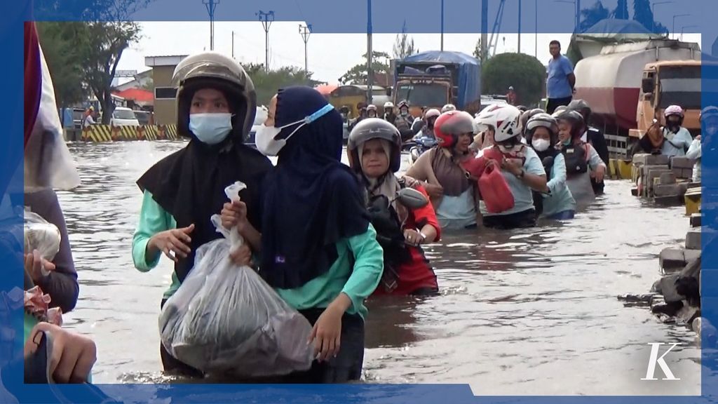
For years, part of the population of Semarang city, Central Java, has had to live with flash floods and seawater overflows known as robfloods. Victims are hoping for a comprehensive solution so that their lives will no longer be under the shadow of the disasters.
Adennyar Wycaksono, 33, a resident of Mangkang Wetan subdistrict, Tugu district, Semarang city, cannot yet forget the flash flood he experienced in 2010. At the time, 10 people were reported dead after having been dragged by the current. One of them was discovered by Aden near his house.
At least over the last two decades, Aden and thousands of people living in the Beringin Watershed (DAS) in Semarang city, have been in apprehensive conditions. It is because the area is recurrently hit by flash floods.
Floods occur as a result of hampered river flow due to high sedimentation. This condition is worsened by the position of Mangkang Wetan in the area of the river bend.
“The latest flash flood took place at the end of 2022, but its impact was not so severe. There were no deaths or damaged houses of local residents as what had been the case in preceding years,” said Aden on Thursday (4/5/2023).
The area’s flooding condition has slightly improved following the normalization of the Beringin River. The Beringin River bend in Mangkang Wetan has also been reconstructed so that it is not too steep. As a result, the river’s overflows can be reduced.
The drains around the house are too narrow. What’s more, they are often clogged by waste.
Living under the shadow of floods has also been experienced by Safira, 26, over the last decade. A resident of Siwalan subdistrict, Gayamsari district, Semarang city, said the worst flood in the area prevailed at the beginning of 2023. The 30-centimeter-high flood inundated her house for two days. In fact, in previous years floods had only submerged the roads leading to her house.
“The drains around the house are too narrow. What’s more, they are often clogged by waste. Actually, it was raining hard early this year. The rainwater could not be collected [in the drains] and even entered residents’ houses,” she said.
KOMPAS/KRISTI D UTAMI
The truck carried a number of workers to pass through the tidal flood at the entrance to Tanjung Emas Port, Semarang, North Semarang District, Semarang City, Central Java, Wednesday (25/5/2022).
Rob floods
Semarang is also overwhelmed by seawater overflows, or rob floods triggered by a rising sea level and land subsidence. A study in the Geophysical Research Letters published in 2022 indicated that the rate of land subsidence in Semarang was around 0.9 to 6 cm per year. The results of a research by the Sepuluh Nopember Institute of Technology (ITS) Surabaya in 2009-2011 on the rise of the sea level showed that the rate of sea level ascent in Semarang reached 12.83 millimeters per year.
One of the areas impacted by rob floods is the Tanjung Mas subdistrict, North Semarang. Amron, 55, a local resident, said robfloods had regularly occurred from 27 years ago. The condition has worsened over the last 10 years. The peak was reached in January 2023 when 17 houses were damaged by robfloods and strong winds.
Every time I made my house higher.
In facing rob floods, residents have two options to choose from: moving to another place or adapting to the condition. Not all residents can afford to move, so some of them choose to remain and adapt.
Amron, for instance, has four times raised the height of his house over the last 27 years. “Every time I made my house higher, I needed at least Rp 50 million. I got the money from a bank loan,” he said.
Three causes
A professor at the Department of Regional and Urban Planning, Diponegoro University, Semarang, Wiwandari Handayani, said the floods in Semarang city had three causes: a minimum number of upstream resorption areas, drainage failure, and land subsidence and sea level rise. The three must be overcome by dissimilar methods.
According to Wiwandari, the minimum number of upstream resorption areas in Semarang is due to the transformation of resorption areas into building zones. Rainwater falls in upstream areas, being unabsorbed into the ground but directly flowing to downstream districts.
“Not all areas, especially resorption areas, can be converted into building zones. If they are turned into building zones, mitigation measures should be made, such as ascertaining that river boundary lines are clear, checking river dams routinely and normalizing rivers periodically,” said Wiwandari.
Residents use carts to carry their motorbikes through tidal floods at Tanjung Emas Port, Semarang City, Central Java, Monday (6/20/2022).
Drainage restructuring for its adjustment to the pattern of rainfall is also needed to overcome its failure. It is because every year the drainage is increasingly demanded as building zones are also rising in numbers.
In order to control rob floods, in her view, integrated infrastructure development is needed; from the building of sea dams, the normalization of rivers and drainage, to the construction of water polders. The education of all parties to reduce the severity of robfloods, like minimizing groundwater exploitation and limiting development in coastal areas, is also necessary.
On several occasions, Semarang Mayor Hevearita G Rahayu claimed to have prepared a number of strategies to surmount floods. For upper districts, the Semarang city government will reorder their spatial layout by cooperating with the Semarang regency administration. This is because most of the rivers in Semarang city come from the upstream of Semarang regency.
“We propose that reservoirs be built in the upper reaches so that the water there will not directly flow down but will make its transit in reservoirs,” she said.
Flood control will also be conducted in the southern part of Semarang. For eastern Semarang, more pumps and sluice gates will be installed, a 250-hectare retention pool will be built and sea dams constructed.
In Semarang’s western part, flood control is to be carried out by normalizing the Plumbon River. The normalization will be realized by the Public Works and Housing Ministry. The Semarang city government is in charge of clearing 11.6 ha of land for this normalization.
Various methods are being adopted in order to free local citizens from disasters, making them no longer fettered by flash floods and seawater overflows.