Java Island is at High Risk of Being Hit by a Large-Scale Earthquake
Earthquakes are one of the disasters that have a high risk of claiming relatively many lives on the island of Java.
This article has been translated using AI. See Original .
About AI Translated Article
Please note that this article was automatically translated using Microsoft Azure AI, Open AI, and Google Translation AI. We cannot ensure that the entire content is translated accurately. If you spot any errors or inconsistencies, contact us at hotline@kompas.id, and we'll make every effort to address them. Thank you for your understanding.
By
BUDIAWAN SIDIK A
·6 minutes read
MACHRADIN WAHYUDI RITONGA
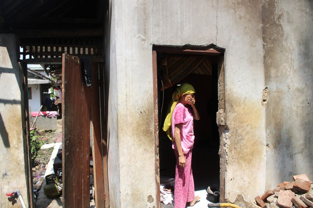
One of the residents observes the damaged kitchen in their house after an earthquake in Sukamenak Village, Sukarame District, Tasikmalaya Regency, West Java, on Sunday (4/28/2024). Some of the houses have collapsed due to the earthquake with a magnitude of M 6.2 and an epicenter 156 kilometers southwest of the center of Garut Regency, on Saturday (4/27/2024) at 23.29.
The island of Java has the highest level of natural disaster risk in Indonesia. Various types of natural disasters ranging from geological disasters, volcanology, hydrometeorology, drought and forest fires are prone to occur on the most populous island in Indonesia. Of the various types of disasters, earthquakes is one of the disasters that has a high risk of causing relatively large casualties.
An earthquake with a magnitude of 6.5 that occurred off the coast 156 kilometers southwest of Garut Regency, West Java on Saturday (27/4/2024) evening is a reminder of how high the intensity of earthquakes is in Indonesia. Based on reports from the Meteorology, Climatology and Geophysics Agency (BMKG) in the period from mid-March 2024 to today, there have been at least 30 earthquakes with a magnitude of more than 5. This means that there is the potential for earthquakes to cause damage, cause casualties and even triggering a tsunami.
Of the 30 recent earthquake events reported by BMKG, at least 8 earthquakes occurred on Java Island, spread from the west to the east region. Not all of these events resulted in damage, but they should still be a joint concern for everyone. Mitigation related to geological disasters must be a priority that is carried out at all times.
The earthquake last night caused some damage in the Tasikmalaya, Garut, Sukabumi, and Ciamis districts. Damage was also observed in the Bandung, West Bandung, Pangandaran, Purwakarta, Tasikmalaya City, and Cimahi City districts. At least 24 houses, 1 junior high school building, as well as several health facilities, places of worship, and government buildings were affected (Kompas.id, 28 April 2024).
The geological natural disaster centered in the Garut area on Saturday night serves as a warning that the intensity of relatively large-scale earthquakes is looming over Java Island. Based on the report from the National Disaster Management Agency (BNPB), at least for the past three years, from 2021 to 2023, earthquakes have occurred that caused relatively large impacts.
In 2021, a magnitude 6.1 earthquake occurred in the southern region of Malang, East Java, which impacted 17 surrounding areas. It was reported that 10 people died, 115 people were injured, and about 2,074 people were displaced. The earthquake disaster that occurred on April 10, 2021 in the afternoon destroyed thousands of buildings, consisting of 606 public facilities, around 8,900 slightly damaged houses, 5,152 moderately damaged houses, and 2,414 severely damaged houses.
An aerial photo of the condition of Cijedil Village, Cugenang District, Cianjur Regency, West Java, which was buried in landslide material, on Tuesday (22/11/2022). More than 17 houses and 30 local residents were buried in the landslide. The process of searching for victims is being carried out manually as heavy equipment cannot reach the location due to difficult terrain.
In 2022, an earthquake with a magnitude of 5.6 struck the Cianjur region in West Java. The earthquake, which had a depth of 10 kilometers on land during the daytime, was felt in 10 districts/cities in West Java. The impact of the earthquake was relatively significant as it claimed the lives of 602 people and 5 others were declared missing. In addition, the event caused injuries to 593 people and forced 114,683 people to evacuate temporarily.
The earthquake in Cianjur has garnered national attention due to the significant damage it caused. It was reported to have caused damage to tens of thousands of buildings, including 56,548 houses, 701 educational facilities, 281 places of worship, 18 office buildings, and 18 health facilities.
The massive scale of damage has forced some communities to be relocated from earthquake fault zones. The government has allocated around 1,600 housing units to be built outside of the fault zones to accommodate people who have moved away from potential disaster areas.
The following year, in 2023, an earthquake with a magnitude of 6 occurred, shaking the Bantul region in the Special Region of Yogyakarta. The earthquake occurred in late June in the sea area, 86 kilometers southwest of Bantul with a depth of 67 kilometers. The earthquake did not have a potential for a tsunami, but it was also felt in 22 districts/cities in Yogyakarta, Central Java, and East Java.
The earthquake killed one person, injured 23 people, and directly impacted 383 families, causing some of them to evacuate. Like other earthquake impacts, this disaster resulted in several damaged buildings. At least 600 housing units, 15 educational facilities, and 10 places of worship were affected by the damage.
Major earthquake disaster in Java
A number of relatively large earthquake events that occurred consistently on the island of Java must be a serious concern to be followed with a number of appropriate mitigation steps. All policy makers, the community and all stakeholders must have awareness regarding anticipating the dangers of disasters. Moreover, the island of Java has been hit by a number of earthquakes which claimed many lives in the past.
Therefore, it is not impossible for the threat of a major disaster to continue indefinitely, demanding that all communities living on the island of Java remain vigilant at all times. The "routine" of large-scale earthquakes that have occurred in recent years should be a serious concern for all parties to improve mitigation efforts in order to minimize casualties.
From the catalog of the Center for Volcanology and Geological Disaster Mitigation, there are several reports indicating some large-scale earthquake events on the island of Java.
Residents from Bantul Regency and Yogyakarta City are flocking away from the southern coastal areas due to panic caused by the issue of a tsunami resulting from a 5.9 magnitude tectonic earthquake on Saturday (May 27, 2006).
One of the biggest incidents was the earthquake in Bantul, DIY, with a magnitude of 6.2 and a depth of 17.1 kilometers on the Sungai Opak fault. The event, which occurred on May 27, 2006, caused fatalities in Yogyakarta and surrounding areas, with a death toll of up to 5,700 people and injuring thousands more. This disaster occurred widely, starting from Bantul and Sleman districts in Yogyakarta, and the Central Java province which occurred in Klaten, Purworejo, and Magelang regions.
In the same year, in 2006, another major earthquake occurred in the coastal region of Pangandaran, West Java, with a magnitude of 7.7. The earthquake, which happened on July 17, 2006, caused a tsunami with a height ranging from 1-6 meters that spread from Pangandaran Beach, Kebumen, Cilacap, to Samas and Parangtristis Beaches in Yogyakarta. It was recorded that there were 550 fatalities and hundreds of people were injured in the coastal areas.
Earthquakes that trigger tsunamis have also occurred in the East Java region, precisely in Banyuwangi on June 3, 1994. The earthquake disaster, measuring 7.2 on the Richter scale, occurred around Rajegwesi, Banyuwangi, causing a tsunami that affected the coastal areas of Banyuwangi, Jember, Malang, Blitar, Tulung Agung, Trenggalek, and Pacitan. As a result of the earthquake and tsunami disaster, which had a wave height of 1-13 meters, it caused casualties of up to 250 people, with 127 people declared missing, 423 people injured, and damaging 1,500 houses and 278 boats.
This series of natural disasters is a sign that the Java Island region is very vulnerable to the threat of geological disasters. This is in line with the high potential threat of other disasters, such as volcanological disasters which are also closely related to geological events. The large number of active volcanoes on the island of Java creates a very high potential for volcanic earthquakes when these mountains erupt. As a result of the volcanic earthquake, a number of houses around the mountain were damaged. Apart from that, it also sometimes causes landslides during volcanic earthquakes, making it dangerous for people on the mountain slopes.
Even volcanic earthquakes can potentially cause tsunamis. For example, when Mount Anak Krakatau erupted in the Sunda Strait on December 22, 2018, it triggered a tsunami that hit the coastal areas of Banten and Lampung. As a result, at least 426 people died, 7,202 were injured, and 23 others were declared missing due to the tsunami's impact.
A number of natural disasters have increasingly confirmed that the island of Java, which is full of economic progress, is very vulnerable to disasters. Therefore, economic development taking place in Java must prioritize the principles of environmental and disaster mitigation. Without considering this, the risk of destruction due to natural disasters will be even higher. Engineering studies and engineering are very necessary so that the economic supporting infrastructure can be strong enough to face the very high threat of geological disasters on the island of Java. (COMPAS R&D)
Editor:
ANDREAS YOGA PRASETYO
Share
Kantor Redaksi
Menara Kompas Lantai 5, Jalan Palmerah Selatan 21, Jakarta Pusat, DKI Jakarta, Indonesia, 10270.
Tlp.
+6221 5347 710
+6221 5347 720
+6221 5347 730
+6221 530 2200
Kantor Iklan
Menara Kompas Lantai 2, Jalan Palmerah Selatan 21, Jakarta Pusat, DKI Jakarta, Indonesia, 10270.