Smoke Covers the City of Pekanbaru
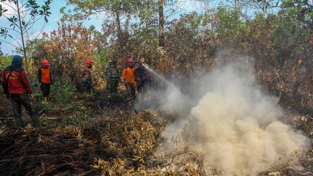
Firefighters from the Riau Province Forestry Task Force try to extinguish flames that burn bushes on peat land in Karya Indah village, Kampar regency, Riau, on Friday (26/7/2019). The Forestry Task Force continues its efforts to put out forest and land fires in a number of areas in Riau province.
PEKANBARU, KOMPAS - Land and forest fires in a number of locations in Riau have become more widespread, increasing the number of the affected areas on Tuesday.
According to data from SiPongi, the website of the Land and Forest Fire Monitoring System of the Environment and Forestry Ministry, forest fires had affected 42,740.42 hectares of areas throughout Indonesia.
The largest fires occurred in Riau (27,683 ha), East Kalimantan (5,153 ha), Riau Islands (4,969 ha), West Kalimantan (2,273 ha), North Kalimantan (792 ha), South Sulawesi (441 ha) and South Sumatra (236 Ha). In Java, the forest fires engulfed 40 hectares of forest on the slopes of Mount Arjuno.
In Pekanbaru city, Riau, on Tuesday, thick smoke covered the city. The visibility at Siak IV Bridge was under 1,000 meters. On Tuesday morning, the view of high buildings from above the bridge only looked like a shadow. However, the people still carried out their activities normally. Almost all motorcyclists didn\'t wear masks.
A spokesperson for the Pekanbaru meteorology office, Marzuki, said that the fog in the sky of the Pekanbaru city came from the remaining smoke from the land and forest fires.
"There is an improvement in weather conditions late in the afternoon. The air mass is improving and the smoke is thinning because there is wind movement," he said.
Based on information from satellite-based remote sensing, there are 130 hotspots throughout the island of Sumatra. In Riau alone there are 60 hotspots. Although the smoke has bleached Pekanbaru, the executive general manager of the Sultan Syarif Kasim II Airport, Pekanbaru, Pratyo Yogi, said the flight arrival and departure schedules were not affected. All airlines continue to operate according to schedule.
The head of the Riau Disaster Mitigation Agency (BPBD), Edwar Sanger, revealed that the smog in Pekanbaru originated from land and forest fires in Penarikan village, Langgam district, Pelalawan regency.
The fires were widespread and could not be controlled. The office has had difficulty monitoring the emergence of fires due to the absence of a patrol helicopter. Riau has six helicopters, but all of them are used for water bombing in the air.
In South Sumatra, over the last two days, the number of hotspots increased significantly. According to data from the South Sumatra Disaster Mitigation Agency, there have been 204 hotspots throughout July. The increase in hot spots occurred in the last three days.
The regional government, the military (TNI) and the police as well as companies in South Sumatra are ready to face the effects of the drought. According to the Meteorology, Climatology and Geophysics Agency (BMKG), rainfall will decrease until next September.
"Nationally, Sinar Mas has prepared a budget of around Rp 300 billion to prevent and mitigate land and forest fires," Mares Prabadi, the head of Sinar Mas Forestry\'s fire management operations in Palembang at the Sinar Mas Asia Pulp & Paper (APP) factory.
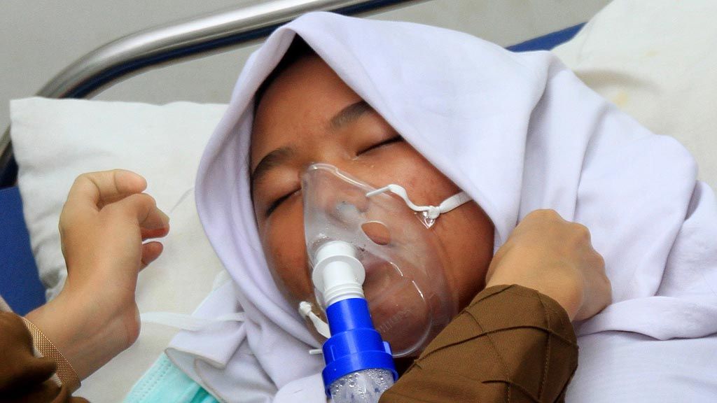
An officer at the Cot Seumeureung Community Health Center (Puskesmas), Samatiga district, West Aceh, Aceh province, provides medical care on Tuesday (30/7/2019) to a patient with respiratory problems caused by thick smoky haze. As many as six students were rushed to the Puskesmas because they had difficulty breathing amid the thick smoke created by forest and land fires.
Kalimantan
In West Kalimantan, fires hit a number of areas. The regional head of the Manggala Agni forest fire operation in Pontianak, Sahat Irawan Manik, said that a fire had engulfed a 5-ha peatland area in Sejegi village, Mempawah Timur, Mempawah regency.
Fires in the area have occurred for four days. On Tuesday morning, a joint team of land and air task forces was trying to put out fires on the peatland. "The cause of the fire is not yet known," said Sahat.
Strong winds have caused the flames, both on the surface and inside the peat layer, to continuously burn. As the fires quickly spread, the task forces faced difficulty in handling them. The land fires have also occurred in the Maya Islands in Karimata district, North Kayong regency, West Kalimantan. The team has not been able to predict the size of the area affected by the fires.
A forest fire helicopter has been deployed. In Tumbang Nusa, Pulang Pisau regency, Central Kalimantan, approximately 50 ha of peatland were burned during the last two weeks. The area consists mostly of a peat swamp.
According to Kompas, the joint taskforces took turns extinguishing the fire. In fact, the government used water bombs from Mi-17 and Mi-8 helicopters, but the smoke continues to spread.
An officer views video feeds in the Sinar Mas forest and land fire monitoring center at the APP Sinar Mas Fire Fighting Command and Training Center, Air Sugihan, Ogan Komering Ilir, South Sumatra, on Tuesday (30/7/2019). APP Sinar Mas has spent Rp 300 billion to anticipate forest and land fires in five provinces. Thus far, fires have gutted 140 hectares of land in South Sumatra and are feared to be spreading during the current dry season.
"Even if it burns, it will not reach its lowest point. The lower part is still moist," the head of the Peat Restoration Agency, Nazir Foead, said on the sidelines of the Peat Restoration Coordination Meeting in Palangkaraya.
In Central Kalimantan, at least 980 ha of land were burned during July. In Pulang Pisau alone, fires engulfed 295 ha of areas with a total of 53 fire incidents.
In Banjarmasin, the head of South Kalimantan Disaster Mitigation Agency, Wahyuddin, said, every day at least 10 hot spots were observed. Land fires also began to occur in Banjarbaru city, Banjar regency, Tanah Laut and Hulu Sungai Selatan.
In Jakarta, the deputy for social vulnerability and disaster impact of the Coordinating Human and Cultural Development Ministry, Dody Usodo said, until Tuesday, five provinces, namely Riau, West
Kalimantan, South Sumatra, Central Kalimantan and South Kalimantan, had declared an emergency status for forest and land fire in the provinces. A similar status was declared by Dumai regency, Siak in Riau, and Sambas in West Kalimantan.
Smoky haze blankets Pekanbaru city, Riau, on Tuesday (30/7/2019), putting buildings throughout the city into shadow.30-07-2019
In Riau, the local government will soon deploy to weather modification technology (TMC) to control the weather. The technology will be also used in other areas such as Central Kalimantan. "At present, even though it is not every day, there are still clouds, so it is possible to use the TMC technology," said Tri Handoko Seto, the head of the Center for Weather Modification Technology at the Agency for the Assessment and Application of Technology (BPPT). ( SAH/ ESA/ RAM/JUM/IDO/ ITA/ WER/AIK/ ICH)