People need to be aware of the impacts of extreme weather. For one, strong winds can result in fallen trees and billboards, damage to house roofs, reduced visibility or even floods and landslides.
By
IRMA TAMBUNAN, AHMAD ARIF
·4 minutes read
IRMA TAMBUNAN
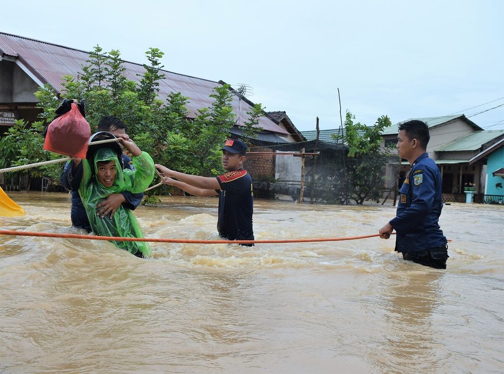
Officers from the Jambi City Fire and Rescue Service helped evacuate flood victims at the Kembar Lestari II Housing, Jambi City, Thursday (12/31/2020). Floods hit parts of the city after four hours of heavy rain.
JAKARTA, KOMPAS - The transition from the dry season to the rainy season may potentially trigger extreme weather. All stakeholders must be wary of strong winds, heavy rainfall and other extreme-weather phenomena that can cause disasters.
Sultan Thaha Jambi Meteorological Station head Ibnu Sulistyono said that Jambi province had entered a transitional period from the dry season to the rainy season. Confluences of winds have been observed, as well as slowing wind speeds and wet atmospheric-humidity conditions.
These conditions result in the potential for rain clouds to form, followed by moderate to heavy rainfall. Lightning and thunderstorms can also simultaneously occur in the afternoon and evening.
“People need to be aware of the impacts of extreme weather. For one, strong winds can result in fallen trees and billboards, damage to house roofs, reduced visibility or even floods and landslides,” he said on Thursday (8/9/2022).
In Jakarta, on Thursday (8/9), the Meteorology, Climatology and Geophysics Agency’s (BMKG) head of climate- and air-quality information Siswanto asked local administrations and communities in areas prone to flooding and landslides to remain alert before and during the peak of the rainy season. This is especially crucial in areas where the rainy season is wetter than normal.
Additionally, for areas seeing an earlier rainy season, he suggested the agricultural sector make adjustments, such as starting an earlier planting season, increasing planting area, harvesting rainwater and filling reservoirs or lakes that will be used for the upcoming dry season.
Rain in Jakarta
Jakarta has been seeing earlier rainfall despite still being in the dry season. This is because of an abundance of water vapor due to the warming sea temperatures and the La Nina phenomenon’s prolonged effect, as well as the active Borneo Vortex and low-pressure centers triggering earlier heavy rainfall.
According to Siswanto, the cloudiness and rain throughout the day in Jakarta and its surroundings are temporary, depending on the activeness of the Borneo Vortex and the low-pressure center. “However, if it rains for only a short period of time, it may potentially rain again after noon due to an abundance of water vapor caused by evaporation from the surrounding waters that are still quite warm,” he said.
KOMPAS/IWAN SETIYAWAN
Dark clouds hung over the sky just before heavy rains hit the Central Jakarta area, Thursday (17/3/2022). Entering the transition season, the potential for heavy rain accompanied by strong winds is still common in Jakarta and its surroundings.
According to a BMKG analysis, as stated by Siswanto, as many as 46 percent or 326 seasonal zones in Indonesia will experience an earlier rainy season than usual. Additionally, 18 percent or 124 seasonal zones will see normal conditions and the remaining 36 percent or 76 seasonal zones will be delayed. The majority of the Java, Bali and West Nusa Tenggara regions will enter the rainy season in September-October, starting from parts of East Java and its mountainous areas, followed by most areas in October and finally the northern coastal areas in November.
Meanwhile, according to rainfall characteristics, 27 percent of Indonesia’s monsoon zones will experience a wetter rainy season than is typical, while 68 percent will see a normal rainy season and 5 percent one less wet than average.
BMKG climatology-analyst Supari said that until August 2022, 78 percent of the seasonal zones are in the dry season and 22 percent have already entered the rainy season. Jakarta and its surroundings are still in the dry season.
“Some of the seasonal zones that have seen rainfall have just entered the rainy season after the dry season. However, there are zones that have not experienced the dry season or have continuously seen rainfall since the previous year,” he said.
Variability
As stated by BMKG head Dwikorita Karnawati in a press statement last month, 2022 has seen climate variability. This was marked by the delay of the dry season’s onset, irregular rain characteristics as well as wet dry seasons in some parts of the country.
According to BMKG data, the La Nina phenomenon currently has weak intensity with an index of -1.25 in August, September and October 2022. La Nina is predicted to persist until at least February 2023. Meanwhile, the negative Indian Ocean Dipole (IOD) phenomenon, which has been ongoing since June 2022, is expected to last until the end of the year.
Supari explained that the analysis of the variability of Indonesia’s surface-sea temperature reflects the effects of global warming. Surface-sea temperatures have been on the rise since mid-April 2022, apart from being caused by La Nina.