Land and Sea Disasters
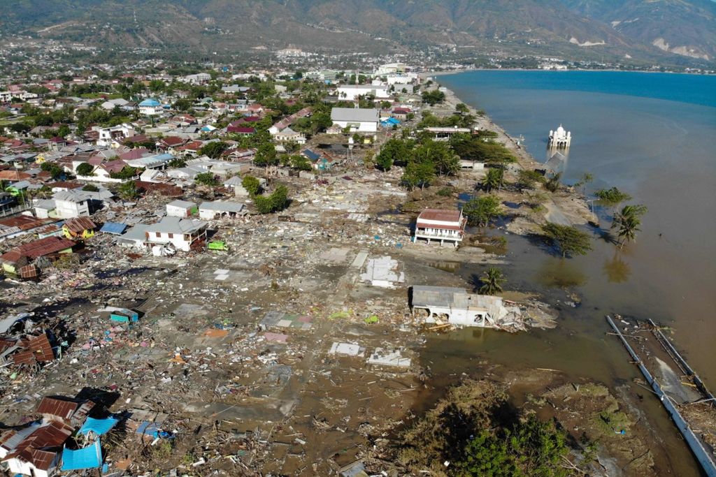
TOPSHOT - An aerial view shows the earthquake and tsunami devasted neighbourhood in Palu, Indonesia\'s Central Sulawesi on October 1, 2018. - The death toll from the Indonesian quake-tsunami nearly doubled to 832 but was expected to rise further after a disaster that has left the island of Sulawesi reeling.
An earthquake and tsunami hit Palu and caused many casualties. The disaster came from the land and the sea. Independent evacuation is the key to disaster mitigation.
Anybody who has been to Palu before it was hit by the earthquake and tsunami [Sept. 28] has surely admired the beauty of this Central Sulawesi city, especially when looking upon it from the nearby hills in the afternoon. The flickering lights of the city lights radiates across the Palu River valley. In the mouth of the bay, the yellow steel of Palu Bridge IV stands as a magnificent icon.
Behind this beauty lay a deadly threat. An active fault line cuts through Palu Valley, which is inhabited by 368,086 people, and into the bay, then continues into the Makassar Strait.
The Palu-Koro fault, which bisects Sulawesi Island from Palu Bay to the Gulf of Bone, is one of the most active faults in Indonesia and shifts 41-45 millimeters every year (Socquet et al., 2006). Compare this to the Great Sumatran Fault, which shifts an average 10 mm per year.
Even though not as many studies exist on the Palu-Koro fault as on the Sumatran fault, warnings have been issued repeatedly to maintain a state of alert on the Palu-Koro. Among the experts is Mudrik Darmawan Daryono, a researcher at the Indonesian Institute of Sciences (LIPI) who submitted a doctoral dissertation on the fault.
When a 6.6-magnitude earthquake on the mainland struck Poso, Central Sulawesi, on Monday, May 29, 2017, Mudrik pointed out that this earthquake was not the greatest threat to Sulawesi, but the Palu-Koro fault. Kompas interviewed Mudrik along with a number of other experts and backed up by data, which was published on Wednesday, May 31, 2017, as “Beware of the Great Sulawesi Earthquake”.
However, when earthquakes will occur cannot be predicted. On Friday, Sept. 28, 2018 at 6:02 p.m. Western Indonesian Time (WIB), a magnitude 7.4 earthquake shook Palu. The epicenter was at a depth of 11 kilometers and 26 km north of Donggala, or 80 km northwest of Palu, along the strike-strip fault zone.
At 6:07 a.m. Central Indonesian Time (WITA), the Meteorology, Climatology and Geophysics Agency (BMKG) issued an early warning for West Palu and Donggala of a tsunami 0.5-3 meters high that was predicted to hit the coastline at 6:22 p.m.
However, the tsunami traveled faster and was higher than predicted. The first wave hit Palu at 6:10 p.m. WITA, 3 minutes after the earthquake. It swept through the Palu coast as the BMKG lifted the tsunami warning at 6:36 p.m. However, when it lifted the warning, the BMKG did not know that a tsunami had hit Palu.
"We lifted the tsunami early warning because according to the tsunami prediction, the estimated time of the tsunami’s arrival in Palu and Mamuju had already passed. The sea level measurement device [tide gauge] in Mamuju [237 km from Palu] had recorded a change of 6 centimeters. The earthquake was
caused by a strike-slip fault system that has historically triggered small tsunamis," said Weniza, the BMKG’s Tsunami Early Warning head.
The BMKG’s move to lift the tsunami warning was widely criticized later, along with the malfunctioning tsunami alarm system (Kompas, 29/9/2018). However, the BMKG works with limited supporting data facilities and uses the predictive pattern technique. The absence of a tsunami buoy made it impossible for the agency to determine exactly when a tsunami might develop and head for land. The tide gauge on Palu’s coast had also malfunctioned.
"A tsunami buoy has never been launched in Palu waters. It was to be installed at one time, but this was hindered by the lack of a budget," said Udrekh, an engineer with the Agency for the Assessment and Application of Technology (BPPT). In addition, the tsunami buoys that had been installed in the Indian Ocean and several other bodies of water were either damaged or missing.
A tsunami researcher from Indonesia who works at New Zealand’s GNS Science, who Aditya Ridi Gusman, who mapped the tsunami pattern in Palu, said that it was common for earthquakes triggered by a sliding fault not to trigger large tsunamis. A tsunami’s height is usually directly proportional to the fault’s vertical movement. But the tsunami that hit Palu was large.
According to Aditya\'s calculations from a tsunami simulation that used only earthquake parameters, the height of the Palu tsunami should have been only 25 cm. He suspected that an undersea landslide had caused an increase in the height of the tsunami.
Separately, BPPT tsunami expert Widjo Kongko said that the increased height of the Palu tsunami could have been a result of the elongated cone shape of Palu Bay. The shape of the bay created conditions that could cause a tsunami to gather greater energy and grow higher than it would on the open ocean.
Localized evacuation response
Apart from analysis on the anomalous height of the tsunami and the controversy surrounding the lifting of the tsunami warning, LIPI Geotechnology Center head Eko Yulianto said the tsunami early warning system was ineffective for Palu. If the local people waited for a tsunami warning from the BMKG, it would come too late for evacuating the coastal area. Because the earthquake’s epicenter was located very close to land, the tsunami arrived in mere minutes.
"I have long proposed that the tsunami warning system should be adjusted to [local] characteristics and hazards. It should not be as it is now, that is, depending on a tsunami warning from the BMKG, which has many weaknesses," he said.
For regions in tsunami hazard zones, such as the zone that stretches across northern Bali to East Nusa Tenggara, Mentawai and the western coast of Sulawesi, the most effective method was to localize evacuation responses. "In these areas, tsunamis can arrive less than 10 minutes following an earthquake," he said.
Residents in these regions must be taught to immediately move away from coastal areas and seek higher ground whenever they feel a strong or long-lasting movement in the earth, without waiting for a warning from the BMKG. The problem is that in the recent Palu disaster, the tsunami that hit its coast was not the only threat.
Aside from the tsunami, most victims were killed when buildings collapsed. The structures collapsed not only as a result of their poor construction, but also due to liquefaction, especially in the Petobo residential area where hundreds of houses sank 3-5 meters into black, liquefied soil. Shortly after the earthquake, the soil in the area liquefied and dragged down the buildings on its surface. At Balaroa, the houses collapsed as though they were being sucked into the ground.
LIPI’s geotechnology liquefaction researcher Adrin Tohari said that the main stretch of the Palu-Koro fault from Sigi to Palu consisted of deposits of young sediments that were loose and not compacted, so they were highly prone to liquefaction when an earthquake occurred. "If there is [another] large earthquake, the area in this zone could collapse again," he said.
This is reinforced by Mudrik Daryono, who found traces of liquefaction from past earthquakes in the area around Palu-Sigi. This finding hardly attracted any attention.
The fact that 19 earthquakes and tsunamis have hit the coast of the Makassar Strait since 1800 should open our eyes and hearts to accept that behind the beautiful facade of Palu is a great disaster hazard that must be taken into account when rebuilding the city.
The Palu and Donggala disasters must be used to urge change in structural patterns, spatial planning and early warning systems so the area can be more resilient to disasters. Other vulnerable cities must also be prepared for the earthquakes and tsunamis that can occur at any time.