The Palu-Koro Fault
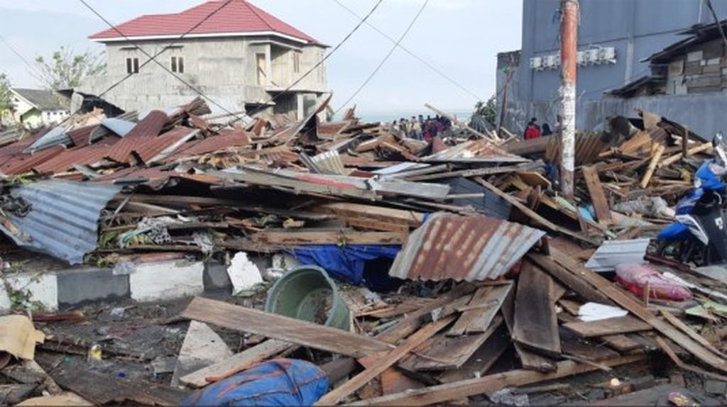
The series of powerful earthquakes that hit Donggala and Palu damaged thousands of homes and caused hundreds of fatalities.
Head of the earthquake information and tsunami early warning division at the Meteorology, Climatology and Geophysics Agency (BMKG)
While the nation was still reeling from the aftermaths of the earthquake that hit Lombok, West Nusa Tenggara (NTB), we were jolted by another strong earthquake and a subsequent tsunami in Donggala and Palu in Central Sulawesi.
A 7.7-magnitude earthquake occurred on Friday, Sept. 28, at 5:02 p.m. Western Indonesia Time, on the coordinate point of 0.18 degree South Latitude and 119.85 degree East Longitude. The epicenter was located 26 kilometers north of Donggala, with the hypocenter being 10 kilometers deep. Based on the later data from 146 analyzed seismometers, the earthquake was revised to have a 7.4-magnitude strength with a hypocenter 11 kilometers deep.
The series of powerful earthquakes that hit Donggala and Palu damaged thousands of homes and caused hundreds of fatalities.
For experts, the destructive earthquakes that struck Donggala and Palu were not strange occurrences. Tectonically, Donggala and Palu sit on the Palu-Koro fault line. Historical records show that the fault line has triggered many destructive earthquakes and tsunamis in Palu Bay and the surrounding regions.
As the trigger of the recent powerful earthquakes in Donggala and Palu, it would be wise for us to dig deeper into the geological structure of the Palu-Koro fault line.
Horizontal fault
The geological-tectonic system in Sulawesi is known to be highly complex. The island’s tectonic pattern is, indeed, famed for its complexity. This tectonic complexity is reflected in the presence of several subduction zones and numerous active faults in Sulawesi, including the Palu-Koro fault.
Palu-Koro is a geological structure with a sinistral strike-slip mechanism. The fault divides Sulawesi into two, each called the west block and the east block, with the dividing line elongating from Palu Bay to Bone Bay.
A study by Indonesian Institute of Sciences (LIPI) researcher Mudrik R Daryono found several segmentations of the Palu-Koro fault, ranging between 15 km and 59 km long. Among these segments are the Palu and Saluki segments on the island’s north and the Moa and Meloi segments on its south. The fault’s southern tip touches the Matano fault line that traverses below Soroako and into the seas. In northern Sulawesi, the Palu-Koro fault runs underneath Palu Bay on to the Makassar Strait, where it is believed to meet with the North Sulawesi Trench.
According to a 2006 study by Socquet, et al., published in the Journal of Geophysical Research, this fault zone moves at a considerably high rate of four centimeters per year. The Palu-Koro fault is
known as one of the most active in Indonesia. Compared to other regional faults in Indonesia, Palu-Koro moves at four times the speed of the great fault of Sumatra.
On maps, you can see that Sulawesi’s eastern block moves relatively northward while the western block moves southward. Such a condition leads to an accumulation of Earth’s crust stress fields along the fault. Tectonically, the Palu-Koro fault is formed as a reaction of the pressures resulting from the collision between the Banggai-Sula microcontinent and Sulawesi Island to its west. The thrusts from Banggai-Sula serve as the main trigger of the regional fault system’s active movements.
Why does Banggai-Sula put so much pressure on Sulawesi? There are two reasons. First is the expansion of the Banda Sea to the northwest and southeast, thereby pushing Buton and Banggai to move westward. Second is the westward thrusts from the Philippine Sea plate, manifested through the presence of the Sorong-Sula great fault. Based on these facts, it seems that Sulawesi – especially its central region – will always be a tectonically active region.
Analysis of the Palu and Donggala earthquakes on Sept. 28, both on the foreshocks, main shocks and aftershocks, shows a close link between the disaster and activities on the Palu-Koro fault. Apart from its shallow hypocenter, a north-south cluster of aftershock spread was also found. Palu-Koro fault’s main characteristic is its sinistral strike slip mechanism, proven by a source mechanism analysis conducted by the Meteorology, Climatology and Geophysics Agency (BMKG).
History of earthquakes and tsunamis
Historical records of earthquakes show at least seven powerful and destructive earthquakes, some of which resulted in tsunamis, in and around Palu Bay. The oldest record of such a disaster was from 1905. Afterwards, powerful earthquakes hit the region in 1907, 1909, 1927, 1937, 1968 and 2012.
The powerful earthquake that hit Palu in 1909 is estimated to have measured above 7.0 on the Richter scale. The earthquake destroyed many homes in the Graben zone in Palu. The shocks were reportedly so powerful that everyone standing immediately fell down. Coconuts and coconut leaves fell from the trees.
An earthquake and subsequent tsunami on Dec. 1, 1927, was sourced from Palu Bay. Apart from causing great infrastructural damage, the earthquake also triggered a tsunami on Palu Bay. Many coastal buildings were heavily damaged, 14 people died and 50 others were injured. The tsunami is known in the oral lore of Palu and Donggala as the incident of “water standing in Palu Bay”.
The powerful earthquake and tsunami on Aug. 14, 1968, had its source on offshore Tambu. It is believed that the earthquake was linked to activities of the Palu-Koro fault. During the earthquake, water in Tambu Bay receded by three meters before a tsunami crashed onto land. A tsunami also hit Palu Bay. Reports at the time said that 160 died in the disaster.
The latest strong earthquake, measuring 6.2 on the Richter scale, occurred on Aug. 18, 2012. The epicenter was estimated to have been between Kulawi and Lake Lindu. In the earthquake, five died and 694 were injured. These historical records of powerful earthquakes and tsunamis should be enough proof of the Palu-Koro fault’s active movements. In the future, earthquake potential in the region will remain high and locals’ awareness must be improved.
Important lessons
There are important lessons to be taken from the earthquake and tsunami in Palu and Donggala in order to reorganize the country’s disaster mitigation strategy in the future. Fatalities and injured victims are not the result of earthquakes, but instead of collapsed infrastructures. Looking at the
high number of buildings sustaining damage in Palu and Donggala, it will be important to make serious and concrete moves to provide earthquake-proof buildings for locals. If not, there will always be fatalities in future earthquakes.
If the hypocenter of an earthquake is located below a coastal area, a tsunami early warning for coastal communities will not be effective as there will only be a short amount of time before the tsunami arrives. The golden period of rescue will be very short. A possible solution is for locals to independently build their evacuation capacity. An independent evacuation concept has proven effective in protecting coastal communities from tsunamis. In such a concept, coastal communities use powerful earthquakes as a warning of an imminent tsunami. Whenever they feel a strong jolt, coastal communities should be educated to get as far away as possible from the shoreline. Whether or not a tsunami actually happens is another problem. Most importantly, if it does, they will be somewhere safe.
The presence of sea-level monitoring stations to confirm the arrival of tsunamis is important in tsunami-prone coastal regions. These stations are important to support the perfect operationalization of a tsunami early warning system, including supporting the decision to end such early warnings.
We cannot yet predict when earthquakes happen, but we need to always be prepared. Socialization of mitigation, education and evacuation training must be done sustainably so that we can live in harmony with nature who often jolts and shakes.