Beware of the potential for a tsunami due to the eruption of Mount Ruang
History records that a tsunami occurred during the eruption of Mount Ruang in 1871 with victims of up to 400 people.
This article has been translated using AI. See Original .
About AI Translated Article
Please note that this article was automatically translated using Microsoft Azure AI, Open AI, and Google Translation AI. We cannot ensure that the entire content is translated accurately. If you spot any errors or inconsistencies, contact us at hotline@kompas.id, and we'll make every effort to address them. Thank you for your understanding.
By
MACHRADIN WAHYUDI RITONGA
·4 minutes read
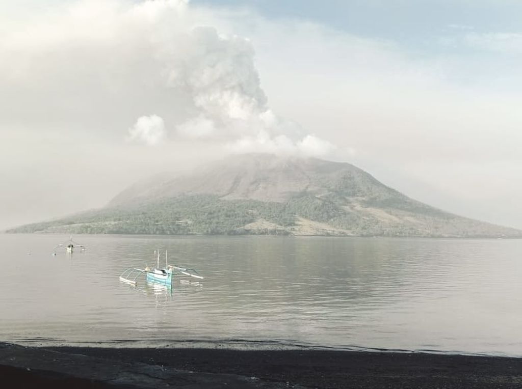
DOKUMENTASI BPBD SITARO
The condition of Mount Ruang in the district of Kepulauan Siau Tagulandang Biaro (Sitaro) in North Sulawesi, which erupted volcanic ash rain on Wednesday (17/4/2024).
BANDUNG, KOMPAS — Residents along the west coast of Tagulandang Island, Siau Islands Regency, Tagulandang Biaro or Sitaro, North Sulawesi, were asked to evacuate because they were vulnerable to being affected by tsunamis, as one of the impacts of the mountain eruption Ruang. Meanwhile, the status of Mount Awu, north of Mount Ruang, is now on alert with a sterile area within a 5 kilometer radius.
Head of the Volcano Observation Team at the Center for Volcanology and Geological Disaster Mitigation (PVMBG) Heruningtyas Desi Purnamasari stated that the increase in Mount Ruang's status to Watch had an impact on expanding the sterile area along the southwest to west coast Tagulandang Island. This area is within a 6 km radius from the peak of Mount Ruang so residents in that area had to evacuate.
"This must be done to anticipate casualties due to the Mount Ruang eruption. "Apart from exposure to volcanic material, tsunamis are prone to occur due to mountain material falling into the sea," said Heruningtyas in Bandung, Thursday (18/4/2024).
Based on historical records of the eruption of Mount Ruang, a tsunami with a wave height of about 25 meters once occurred on March 3, 1871. The event hit the coastal areas of Tagulandang Island and surged up to 180 meters from the shoreline.
At that time, the death toll reached 400 people. This disaster happened before the eruption of Mount Ruang on March 9 and 14, 1871, which erupted rocks and sand. The eruption also damaged the last recorded civilization in 2002. The event caused damage to land and settlements and triggered evacuations.
"Until Thursday morning there had not been a tsunami. "However, we still need to be careful," said Heruningtyas.
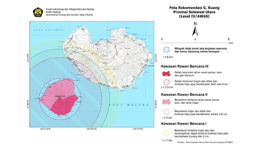
PUSAT VULKANOLOGI DAN MITIGASI BENCANA GEOLOGI
Screenshot of the Recommendation Map for Mount Ruang at Warning Level issued by the Center for Volcanology and Geological Disaster Mitigation, Wednesday (17/4/2024).
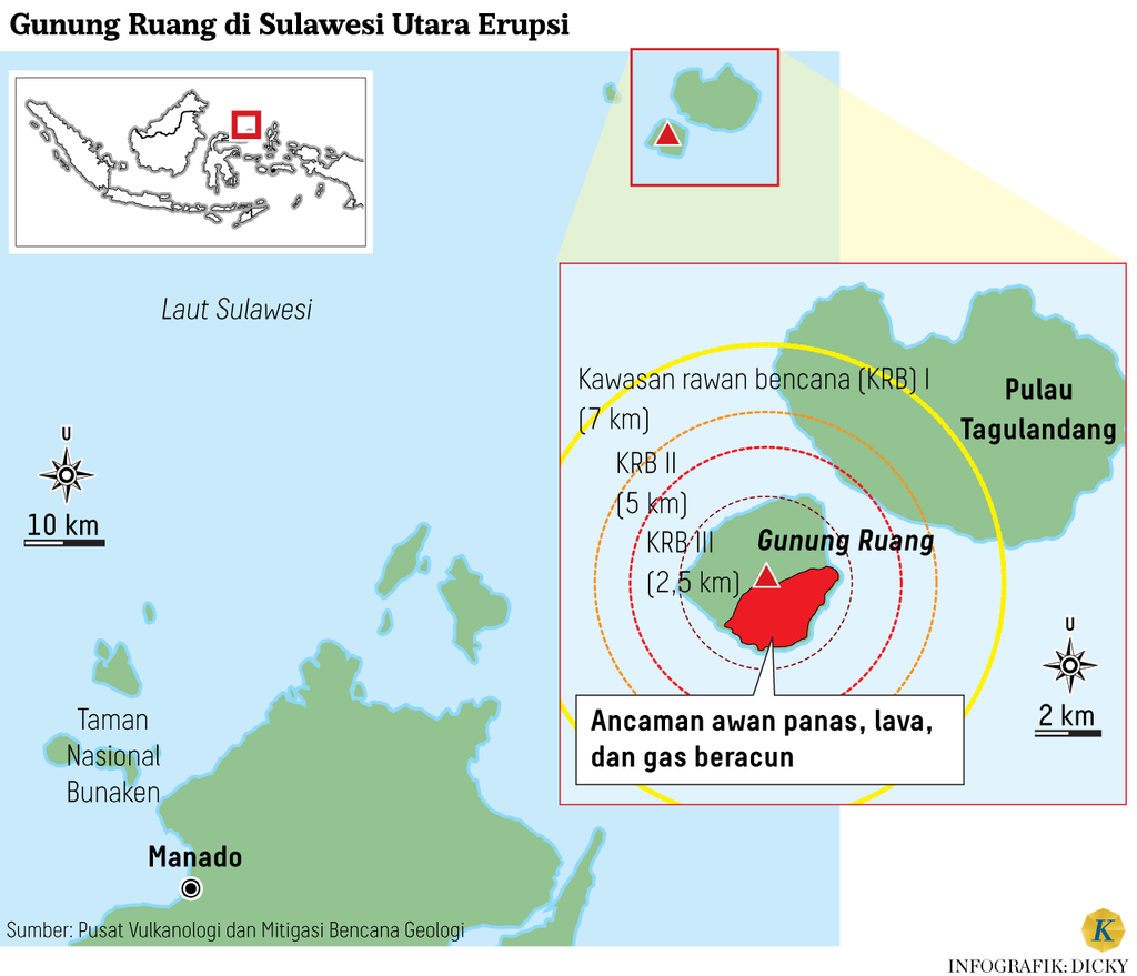
Based on the Mount Ruang Recommendation Map at Level IV or Alert, residents in the southwestern and western coastal areas of Tagulandang Island have been asked to evacuate. Residents are directed to go to the eastern and central parts of the island.
Heruningtyas stated that they are still waiting for updates on the data regarding the additional number of residents affected by the eruption of Mount Ruang. When the status was at Alert level, the number of affected residents was 838 individuals from Limpatehe Village and Pumpente Village in Tagulandang Subdistrict.
"If we look at the expansion of the sterilization area, the number of affected residents will certainly increase. However, most have already evacuated on their own, so the detailed counting is still ongoing," he said.
Series of eruptions
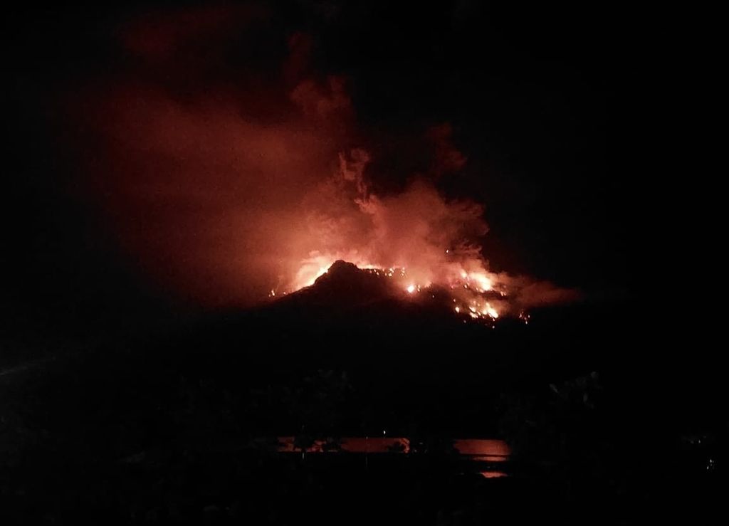
DOKUMENTASI BPBD SITARO
The eruption of Mount Ruang in the Kepulauan Siau Tagulandang Biaro (Sitaro) Regency in North Sulawesi occurred on Tuesday night (16/4/2024). Hundreds of residents were evacuated.
A series of eruptions from Mount Ruang have occurred since Tuesday (16/4/2024). According to the Geological Agency's records, smoke from the crater, with a height of 200-500 m from the summit, began to be visible on Tuesday morning.
An eruption with weak intensity occurred at 13:37 Wita. Subsequently, explosive eruptions began at 21:45 Wita. The estimated height of the eruption column reached 2,000 m from the peak.
A similar eruption occurred again on Wednesday (4/17/2024) at 01.08 Wita with an eruption column reaching 2,500 m. This time it was accompanied by a rumble. At 05.05 Wita, an eruption as high as 1,800 m occurred on Mount Ruang.
According to records from PVMBG, as of Wednesday from 00.00-12.00 WITA, there were 373 volcanic earthquakes, 564 shallow volcanic earthquakes, and one local tectonic earthquake occurrence. Even between 12.00 and 20.15 WITA, there was one eruption earthquake and continuous volcanic tremors with a dominant amplitude of 55 millimeters.
This eruption resulted in the projection of rocks (pyroclastic) in all directions, which could be followed by hot clouds or effusive eruptions (lava flow). Residents on Tagulandang Island, especially those near the coast, should be cautious about the projection of pyroclastic rocks and hot clouds.
On the same day, there was an eruption reaching a height of 2,500 m from the summit at 6:00 pm Wita. An explosive eruption with a column height of gray to black color occurred around 3,000 m above the summit at 8:15 pm Wita accompanied by thunderous sounds and earthquakes.
"The latest record was on April 17, 2024 at 8:39 PM Wita. There is a possibility of impacts from the eruption materials and disrupted electrical networks. We will immediately install a replacement station to ensure monitoring continues," he explained.
Head of the Geological Agency, Muhammad Wafid, stated that as of Thursday (18/4/2024) at 12:00 Wita, the eruption of Mount Ruang was observed in the form of continuous smoke that was white to brownish with relatively weak intensity. However, from monitoring results, the volcanic activity of this mountain is still high with the potential danger of explosive eruptions that may occur.
"This eruption produced eruptions of rocks (pyroclastic flows) in all directions which can be accompanied by hot clouds or effusive eruptions (lava flows). The community in Tagulandang Island, especially those near the coast, are advised to be cautious of rock eruptions until hot clouds arrive," he said.
Wafid also urges the community around Mount Ruang to use masks. The goal is to avoid exposure to volcanic ash that can disrupt the respiratory system. His team will also continue to periodically evaluate or when there are significant changes.
Nearby mountains
Apart from Ruang, the activities of two other mountains in North Sulawesi, namely Karangetang and Awu, have also increased. According to Heruningtyas, the status of Mount Awu, which is about 100 km from Mount Ruang, has increased from Waspada to Siaga since April 16, 2024 at 6:00 pm Wita. The sterile area for residents is located 5 km from the peak.
"We did not expect the increase in seismic activity this quickly in Awu, whereas despite the increase, Karangetang's status is still on alert," he said.